Grenoble
History and description
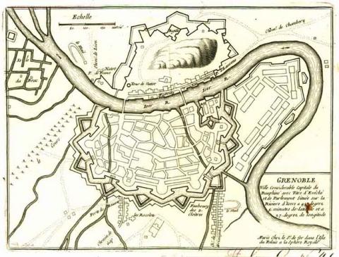
Founded in Isère of a Gallo-Roman vicus, Grenoble had its first protective urban wall build from 296 AD, under the Late Antiquity. The Roman fortifications remained until the 16th century and were modified on multiple occasions. Initially, by expansion in the 13th century at the spot where the current Fine Arts Museum stands, followed by the addition of a protective tower for the Porte Saint-Laurent (gate) and the bridge on the Isère in 1382, and finally, in 1444, with the extension of the town towards the south-east. In the latter case, a stronghold was added at the same time on the hill of Rabot to monitor the road to Lyon. Taken by the protestant Lesdiguières in 1590, the town saw the former urban wall replaced, initially by a first bastioned rampart, wider than its predecessor, and with three times the internal surface area. Two new gates were also installed in this protective wall on the right bank: the Porte de France and the Porte Saint-Laurent (gates), along the Isère. A first high fortification was created on the hill of the Bastille which dominates Grenoble, in the form of a redoubt, which was linked to the urban wall by bastions and projections. A square citadel was added to the east, near the left bank of the Isère. An initial expansion of this bastioned protective wall was performed in 1639 by the engineer Jean de Biens, under the orders of the grandson of Lesdiguières, Francis de Créqui. The expansion was implemented to the south-east by the addition of two complete bastions, connected to the urban wall by two demi-bastions. Two ravelins completed these ramparts in 1661. The remainder of the urban wall was modernised, while Jean de Biens took on the task of taming the streams of Verderet and Draguet, as well as containment of the Drac, a tributary of the Isère, to protect the town against flooding. A second expansion of the protective was implemented towards the west between 1670 and 1675, the Créqui expansion, named as such because the work was overseen by Francis de Créqui.Vauban visited Grenoble on two occasions: in 1692 and 1700. During his first visit, which came after an attempted Savoy siege, he cites the town of Grenoble as indefensible given the poor state of its fortifications and the military land occupied by residents. To remedy matters, his project involved plans to eliminate the encroachments on the urban wall, to seal dykes back up where they were breached, to effectively knock down and do away with the glacis, deepen the moats, add ravelins and create pre-moats. For the Bastille, he favoured the replacement of the former redoubt with a new fort including floors on multiple levels. In 1700, he designed additions to his first project: demolishing the citadel of Lesdiguières to replace it with barracks and magazines, and expanding the urban wall towards the south to include the adjacent suburbs. However, few of these modifications were actually completed: the buttresses on the underside of the curtain walls, four ravelins and two powder magazines were constructed between 1692 and 1700. The fort de la Bastille was not completed due to lack of funds. As for the occupation of military ground by civilians, this continued and expanded in the 18th century.
Forty years after the death of Vauban, the engineers of Louis XV proposed in 1747 to excavate a canal which would divert the Isère. While one aim of the project was to bolster flood defences, it was also intended to represent a hydraulic entrenchment. Multiple defensive works also had to be constructed along the canal. This project was also unfinished. It was not until the Restoration in 1816 that the projects initially set out by Vauban could be completed: General Haxo designed the fort de la Bastille from 1818 to 1823 and the engineer Tournadre expanded the urban wall towards the south, which followed the broad outlines of the projects Vauban had set out. This construction got underway in 1824 and was completed under the July Monarchy in 1844. After 1873, Colonel Cosseron de Villenoisy, working alongside General Séré de Rivières, constructed a belt of six peripheral forts on the surrounding highlands.
Current state
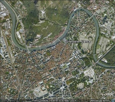
The urban wall of Grenoble was razed to the ground in 1877. Avenues and a railway station now stand in the sites of the former installations. However, a powder keg constructed in accordance with the projects of Vauban still remains, as well as some medieval remains. The Fort de la Bastille has been largely preserved and converted to allow people to explore. A cable car links it to the town. As regards the peripheral forts, those of the Bourcet, Comboire and Saint-Eynard have benefited from restorations and redesigns and can be visited. The three others, the Fort du Murier, the Fort de Montavie and the Fort des Quatres-Seigneurs, are in ruins. The relief map constructed from 1838 to 1848 at a scale of 1/600, is preserved at the museum of relief maps in Paris, but is not on show.
Grenoble
Grenoble
45° 11' 3.2204" N, 5° 40' 49.8745" E
Type
urban wall, fort
Department
Isère
Region
Auvergne-Rhône-Alpes
Bibliography
- BARDE (Y.), Sentinelles des Alpes, citadelles et fortifications, Rennes, 2010, éd. Ouest-France.
- BORNECQUE (R.) et FAUCHERRE (N.), La route des fortifications dans les Alpes, Paris, 2006, coll. Les étoiles de Vauban.
- BORNECQUE (R.), Vauban et les Alpes, Saint-Léger-Vauban, 1995, éd. Association des Amis de la Maison Vauban.
- BORNECQUE (R.), L’architecture militaire dans les Alpes et le Jura (XVIIe et XVIIIe siècles), Lille, Université de Lille II, 1982, (Thèse de Doctorat).
- Vauban et ses successeurs en Savoie et en Isère, Paris, 2001, éd. Association Vauban, (actes du colloque de 1998).

