Mont-Dauphin
History and description
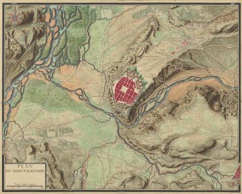
Mont-Dauphin is one of the nine towns constructed almost entirely in accordance with the projects of Vauban. Its creation was intended to allow control of the confluence between the Durance and its tributary the Guil. Another reason was to facilitate monitoring of the col de Vars (Vars peak), used in July 1692 by the armies of Duke Victor-Amédée of Savoy for launching raids in the Ubaye and the Queyras, during the three month attack launched by the army of Savoy against the Dauphiné, during the war of the League of Augsbourg. The selected site was the plateau de Mille-Aures at an altitude of 1,050 metres, which dominated Guillestre, a town threatened during the Savoy invasion of 1692. The plateau de Mille-Aures was gently-sloping and limited in space by cliffs or steep scree on three sides. A relatively wide passage connected it to the plateau d’Eygliers. The site had plenty of sunshine, cultivable land and abundant resources. When selecting it, Vauban went on-site and was advised by Catinat, an officer with experience of doing battle with the army of Savoy.The project of Vauban from 1693-1700 consisted in creating a fortified town from nothing, roughly octagonal in shape, including two fronts with tenailles, a central bastion and two demi-bastions. These two fronts were preceded by dry moats and a covered way with traverses. The protection of the town was ensured by its position on a reverse slope, making it invisible from the neighbouring plateau. The remainder of the urban wall was a section with five flat bastions, which straddled the edges of the plateau, a gate equipped with a drawbridge, a vaulted corridor and with organs, a perfected portcullis. Inside, multiple barracks were thought to have been constructed along the ramparts and a civilian town based on an orthogonal was thought to have taken shape. Quotations from 1693 indicate the intention to use the site for the construction of a Governor’s Residence, a mill, a church, a bridge on the nearby Guil and paving the streets. Vauban drew up plans for all these elements. However, he neglected to make provision for two downsides of the site: firstly, the wind (plateau de Mille-Aures: plateau of a thousand winds). Subsequently, the subsoil was not rocky but made up of stones and mixed sand. These two factors prompted Catinat, who implemented and oversaw the construction, to reduce the depth of the moats and secure the stone work, which tended to collapse relatively swiftly, due to the lack of stability of the subsoil and the fact that the wind made the site fragile. In 1700, Vauban made a second on-site visit. He recommended that the ramparts, the flanked portion of which at the cliffs remained unrealised, be sealed off and also proposed adding three redoubts before the main front and razing away any uneven parts in the sloping bank. He also proposed the establishment of an redoubt on the left bank of the Guil. However, these construction projects were only partially completed. While the two redoubts were finished, the annexing of Ubaye to France in 1713, following the War of Succession of Spain, saw the frontier retreat far from Mont-Dauphin. This, combined with the cost of repairs for the construction already completed, led to the overall construction project being abandoned.
Thirty-two years later, in 1745, a French defeat saw renewed interest in Mont-Dauphin based on the need for a solid support base. The arsenal was constructed from 1751 to 1757. The front of Embrun was achieved, a gate was installed and casemated barracks were constructed (from 1765 to 1785). In 1749, the engineer Heuriance proposed the completion of the town, based on the projects of Vauban. However this plan did not come to fruition; the church, commenced in 1693, remained incomplete. Only the chorus was completed and walled at the level of the transept. The bell tower, the nave and the transept remained in outline form (the sections of walls already constructed were dismantled in the 19th century during a modification of the shooting ledge). Between 1791 and 1802, General Le Michaud d’Arçon constructed a lunette for crossfire including a casemated tower, a prototype of the Lunettes of Arçon. During the 19th century, the adaptations made due to progress in artillery required modifications made to the new battery sites.
Current state
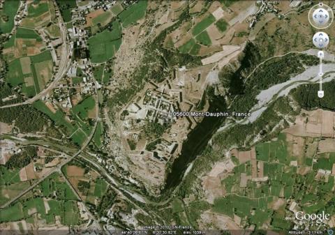
The fortified town of Mont-Dauphin still exists, in its unfinished state of the mid-18th century. The constructed portions of the urban wall remain intact; likewise the lunette of Arçon. In the town, the two barracks constructed under Vauban and until the end of the Former Regime still remain. The powder keg was covered in earth in the 19th century and an arch-buttress was constructed to prevent the collapse of a flank of the caserne Rochambeau (Rochambeau barracks) in 1783. Only one portion of the civil constructions initially planned was realised. The former wing of the arsenal and the maison de l’Ingénieur (house of the engineer) disappeared in June 1940 following accidental bombardment by an Italian plane. Today, completely demilitarised, the small town, included on the List of World Heritage as part of the fortifications of Vauban, is jointly managed by the commune and the Centre of National Monuments. The latter offers various shows and guided visits to the ramparts, military buildings and tunnels. The relief map of 1709 to a scale of 1/600, repaired in 1763, was preserved but is not on show.
Mont-Dauphin
Mont-Dauphin
44° 40' 8" N, 6° 37' 30" E
Type
new town
Engineers
Sébastien le Prestre de Vauban, Nicolas de Catinat, Rostaing, Jean-Claude Éléonore le Michaud d’Arçon
Department
Hautes-Alpes
Region
Provence-Alpes-Côte d'Azur
Bibliography
- BODIN (B.), FAUCHERRE (N.), Vauban, les sites majeurs, Grenoble, 2007, p.58-63.
- BORNECQUE (R.), L’architecture militaire dans les Alpes et le Jura, Paris, 1976, (thèse de doctorat présentée à l’université de Paris IV en 1976).
- BORNECQUE (R.), Vauban et les Alpes, Saint-Léger-Vauban, 1995.
- BORNECQUE (R.), FAUCHERRE (N.), LEMAITRE (P.), La route des fortifications dans les Alpes, Paris, 2006.
- CROCHET (B.), RIVET (G.), Vauban et son héritage, guide des forteresses à visiter, Rennes, 2014.
- FOUILLOY-JULLIEN (I.), « Mont-Dauphin » in Vauban et ses successeurs en Briançonnais, Paris, 1995.
- Ouvrage collectif, Place forte de Mont-Dauphin, Mont-Dauphin, 2001.
- RIOTON (R.), La zone de protection du Patrimoine architectural et Urbain de Mont-Dauphin (Hautes-Alpes), s. l., 1995, 1ere partie.
- TILLIER (A), Réutilisation de la place forte de Mont-Dauphin (Hautes-Alpes), Gap, 1986.
- WARMOES (I.), Le Musée des Plans-Reliefs, Paris, 1997, p.48.

