Longwy
History and description
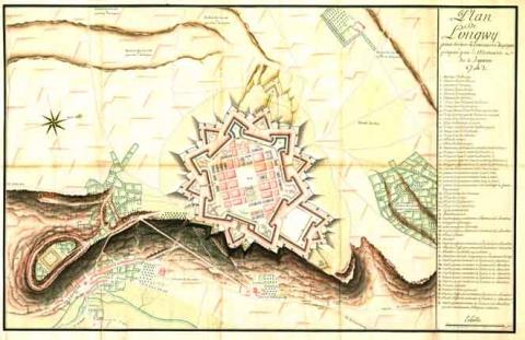
The agglomeration of Longwy emerged at the end of the High Middle Ages, and had its own castel site in around the 11th century. The original village developed on a widened plateau and was eventually linked to the Chiers valley, divided into two towns: Longwy-Haut (the Old Longwy) and Longwy-Bas (in the valley of the river). In the 15th century, the castle of Longwy was one of the most important in the region. It was partially destroyed in 1646 during the Thirty Years War, during which Longwy became French. The site remained sparsely populated up until 1679, hence no modern fortifications were constructed until this time. A medieval urban wall surrounded the small town of Longwy-Haut while Longwy-Bas was never fortified. Longwy-Haut had an urban wall built with straight walls and round towers, but the date when this protective wall was constructed is unclear, likely around the same time as the castle. This urban wall, the town and the castle all disappeared in 1672, razed to the ground by the French.In 1678, after the combat in the war of Holland came to an end and the set-up of the Pré Carré by Vauban to the north-west, Louis XIV decided to reinforce the border area to the north of Lorraine. The engineer Thomas de Choisy, a colleague of Vauban, was sent on site by Louvois, the War Minister. Near to the fortress of Luxembourg, held by the Spanish, and the Saint-Empire frontiers, the Longwy site was deemed ideal by Choisy for the construction of a fortress. Accordingly, he occupied the extended plateau of Longwy by razing the remaining parts of the castle and the small pre-existing medieval town. A new fortified town, given the same name as the village, was constructed on the plateau. The first project of Thomas de Choisy consisted in creating a square or pentagonal town. Following the signing of the treaty of Nimègue in 1679, he drew up a second project which was implemented: namely, a new hexagonal town, equipped with six hollow orillon bastions, six ravelins and a hornwork. Five curtain walls were protected by tenailles, except that of the south-east front with a sheer drop, the bastion flanks of which were straight parallel to the ramparts. The covered way included a counterscarp and incoming parade grounds. Two gates, namely Burgundy and France, were included in this urban wall, symmetrically laid out to the north and south. Vauban was opposed to this project and suggested an alternative, but was overruled by Louis XIV. Deferring to the king, Vauban thus applied the project of Thomas de Choisyin, with some slight modification. The two western fronts included tenailles while a third, to the south, was equipped with a rampart. The covered walkway included traverses. The ravelin to the north-west was preceded by a lunette. In the interior, the new town was constructed according to an orthogonal outline with a central parade ground, equipped with an experimental well. The eleven barracks were grouped in rectangular islets closest to the curtain walls; the governor’s residence and the church were situated in the centre, alongside the parade ground. Also constructed there was an arsenal, a military bakery and a siege well (which was reconstructed in 1739) supplied by tunnelled layers coming from neighbouring sources. The garrison of Longwy housed 3,600 soldiers, namely double the number of civilian residents, the latter being accommodated in thirty-two urban islets. The military buildings were constructed in twenty other urban spots, eight of which bordered the curtain walls to the north and south, and four by curtain walls. The others were spread around the town. After the treaty of Rijswick of 1697 and the return of Luxembourg to the Netherlands, Vauban filed a submission to complete the spot and an expansion project intended to make Longwy a location as expansive as Luxembourg and with a garrison equal in size. For this purpose, he proposed refortifying the site of the Old Castle and surrounding the plateau of the crown work including four bastioned fronts with straight flanks, ravelins, tenailles and traverses. The village of Lower Longwy also required modest ramparts. However, the required repair work was all that was completed due to lack of funds.
Over the centuries that followed, the fortifications of Longwy were not significantly modified. The capture of Luxembourg between 1684 and 1698 meant it was downgraded to second line status, which prompted a slowdown in construction. Multiple buildings, including the town hall, were not completed until the 18th century. In 1731, the military bakery had a siege cistern fitted. The construction of the years 1790 and 1810-1820 was limited to repairing the damage caused by sieges of 1792 (by the Austrians) and 1814-1815 (by the victorious allies of Napoleon).
Current state
Two thirds of the protective wall, including the Porte de France, still stands. They are preserved and regularly maintained. The whole facility is today a freely accessible city park. An adventure park has also been added. The tourist office can arrange guided tours. The Governor’s residence is used as the town hall, while the Saint-Dagobert church is preserved. Its observatory lost a floor during the Prussian siege from 1870-1871. The well of 1739, the military bakery, the siege cistern as well as some barracks all survive, as the town planning map. The entire set has been included since 2008 on the World Heritage List as part of the fortifications of Vauban. A model of the fortifications of the town is also on show at the municipal museum. The town of Longwy established a master plan to evaluate the whole of the urban wall, part of which had disappeared following multiple bombardments. Synergies with Sarrelouis in Germany, but also with other heritage (natural and industrial) of the territory were ongoing to ensure a more integral evaluation of the town.
Longwy
Longwy
49° 30' 52.403" N, 5° 46' 4.4695" E
Type
urban wall and new town
Engineers
Sébastien le Prestre de Vauban, Thomas de Choisy, Raymond-Adolphe Séré de Rivières
Department
Meurthe-et-Moselle
Region
Grand Est
Bibliography
- BODIN (B.), FAUCHERRE (N.), Vauban, les sites majeurs, Grenoble, 2007, p. 53-55.
- DALLEMAGNE (F.), L’Art de la fortification, dans monuments historiques : Vauban et l’architecture militaire, n°126, 1983.
- DE ROUX (A.), Villes neuves, urbanisme classique, Paris, 1995.
- FAUCHERRE (N.), Places fortes, bastions du pouvoir, Paris, 1996.
- MARTIN (P.), La route des fortifications dans l’Est, Paris, 2007.
- SALZMANN (J.-P.), Vauban, militaire et économiste sous Louis XIV, t. II : Vauban et Longwy à l’époque de Louis XIV, les Guerres de Louis XIV, Luxembourg, 2009, (actes du colloque organisé par la Commission Lorraine d’Histoire militaire à Longwy, les 29 et 30 septembre 2007).
- SANGER (V.), Military town planning under Louis XIV: Vauban’s pratice and method, New York, 2000.
- TRUTTMAN (P.), Fortification, architecture et urbanisme aux XVIIe et XVIIIe siècles, Thionville, 1975.
- ZELLER (A.), L’organisation des frontières du nord et de l’est de la France au XVIIe siècle, Paris, 1928.

