Sélestat
History and description
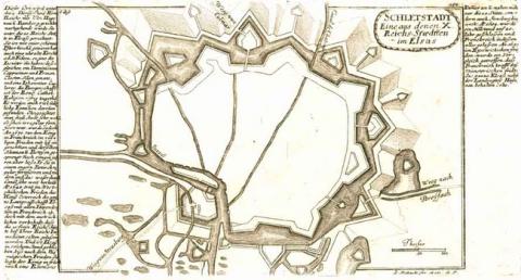
A town of Carolingian origin, built on the left bank of the Ill, affluent of the Rhine, Sélestat only really got into its stride in the 11th century, when a priory was established there. This expansion prompted the Germanic emperors to confer on it the title of imperial town in 1217. Following that, the first urban wall was constructed. This urban medieval wall was rebuilt three times (in 1280, then in the 14th and 15th centuries), until the town was captured by the France of Louis XIII in 1634. Inside, two arsenals equipped the town, the arsenal de Sainte-Barbe (1534) and the arsenal de Saint-Hilaire (1518). The town housed a commandery of the Order of the Hospitaliers since the 13th century. In 1673, the urban medieval wall was finally demolished during the war of Holland. Five years later, France under Louis XIV officially acquired Sélestat under the treaty of Nijmegen.In 1680, Vauban decided to reconstruct Sélestat in order to create the fifth urban wall there. The engineer Jean Tarade designed the plans and ensured monitoring of the construction, which finished in 1691. The new urban wall possessed eight bastions, six ravelins, a counterguard, seven redoubts and three gates. The moats were flooded using river water. In 1698, Vauban set out a project of fortification for Sélestat, which was not applied.
In the 18th century, the urban wall was not subject to any significant modification. The only military construction was that of the arsenal de Saint-Hilaire, which was reconstructed in 1785 on the orders of Marc-Gaspard Capriol de Saint-Hilaire, artillery commander of Sélestat. The tour des Sorcières, vestige of the urban wall of the 13th century, transformed by Tarade and restored in 1675, was transformed into an artillery depot in 1774.
Current state
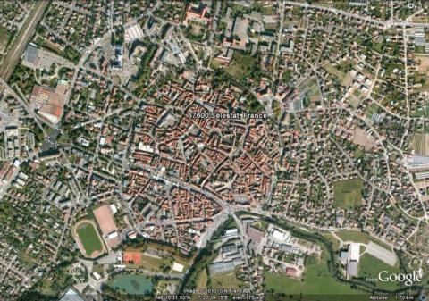
The stronghold of Sélestat was demolished after the Prussian siege in 1870. The only surviving remnants are the porte de Strasbourg possessing a monumental entrance with triangular frontons and pilasters, as well as two bastions and their curtain wall, and the remains of the porte de Colmar. The medieval tour des Sorcières (1217) and the new gate (1280) are the last visible remains of the medieval ramparts. The two arsenals are preserved. Of the Hospitaliers commandery, however, all that is left is the maison des Moines-chevaliers (house of the Warrior Monks) and the maison du prieur (house of the Prior).
Sélestat
Sélestat
48° 15' 34" N, 7° 27' 15" E
Type
urban wall
Engineers
Sébastien le Prestre de Vauban, Jacques Tarade
Department
Bas-Rhin
Region
Grand Est
Bibliography
- FAUCHERRE (N.), Fortifications de Sélestat (Bas-Rhin), s. l. n. d.
- PONS (J.), « Les fortifications de Sélestat (1676-1874) : leur construction » in Annuaire de la Société des Amis de la Bibliothèque humaniste de Sélestat, Sélestat, t. 21, 1971, p. 9-30.
- WERLE (M.), REUTENAUER (F.), « Sélestat (Bas-Rhin) » in Archéologie des enceintes et de leurs abords en Lorraine et en Alsace, Revue Archéologique de l’Est, Dijon, suppl., 2008, p. 287-304.

