Saint-Omer
History and description
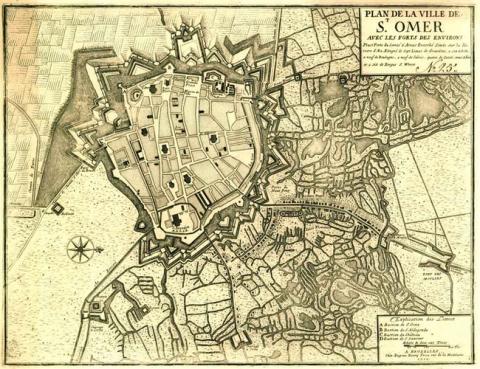
A town of Merovingian origin, Saint-Omer has been fortified since 900, when a castle and a market were installed around the collegial and surrounded by an urban wall of earth and wood. This urban wall was replaced by another, larger, around 1200. Initially in wood and earth, it was constructed from 1338 and equipped with towers. Following these reinforcements, the end product was a protective wall following an irregular route and with seventy towers, walls with arcades and battlements. Eight gates allowed access. From 1533, this urban wall was readjusted to the requirements of artillery with cannon balls: the irregularities were cancelled out, and eaves behind the west moat. The first bastion was constructed under Philippe II of Spain in 1559-1561. This was the bastion of Egmont, which replaced the medieval castle by enclosing it. In 1577, platforms for cannons were installed and the walls were lowered and remodelled. From 1611 to 1625, under the Archdukes Albert and Isabelle, governors of the Netherlands Spanish, multiple other bastions and ravelins completed the defences. Certain projects remained unrealised due to lack of funds, but what was created was sufficient to repel a French siege of seven weeks in 1638. The Spanish reinforced the defensive installation in 1666 by the construction of the fort Saint-Michel and new detached works in front of the western front. In 1677, during the war of Holland, Saint-Omer was besieged again by the French and taken by the brother of King Louis XIV.From 1678, Vauban completed the ramparts of Saint-Omer. Under his direction, the engineers Robelin and Richerand transformed the bastion of Egmont and the medieval castle into an entrenched construction. The covered ways were adjusted and traverses were constructed. The flood defence system was improved by the creation of the crown of Maillebois to protect the dykes. All the moats surrounding the site were flooded.
Current state
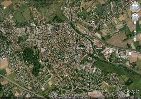
The stronghold of Saint-Omer was taken apart in 1892. Nothing has survived except the bastion of Saint-Venant, situated to the north of the emplacement of the entrenched bastion of Egmont (vanished), two curtain walls, a ravelin and the remaining parts of a hornwork. Everything was incorporated into a city park in the town. The barracks and arsenal, known as the Foch district, situated near the station are also worthy of mention. It was constructed from as early as 1776 for the oldest constructions and finally completed in 1999. All these buildings are currently awaiting restoration. A business park is starting to invest in the area. The relief map drawn up in 1758 is preserved at the museum of Relief Maps in Paris but is not on show.
Saint-Omer
Saint-Omer
50° 46' 4.3327" N, 2° 14' 10.1936" E
Type
fort, then entrenched camp with hydraulic defence
Department
Nord
Region
Hauts-de-France
Bibliography
- Au fil de la ville, Saint-Omer, 2001.
- BRAGARD (P.), A la découverte des villes fortifiées : les fortifications de Saint-Omer, Dunkerque, s. d.
- BRAGARD (P.), CHEUVA (P.), COMBEAU (Y.) et al., Etoiles de pierre. Voyage en Nord Pas-de-Calais, Villeneuve-d’Ascq, 2003.
- BOCQUILLON (L.), A la découverte des anciennes fortifications de Saint-Omer, Cambrai, 2001, éd. Nord Patrimoine.
- Métamorphoses autour de la gare, un quartier entre ville et marais, Saint-Omer, 2001, (catalogue d’exposition).
- Septentrion, le guide : entre Mer du Nord et Meuse, 19 villes fortes s’unissent pour inventer un idéal urbain, s. l., 2008, p. 52-53.

