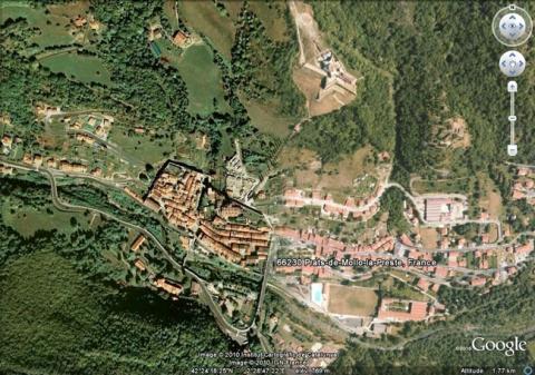
Prats-de-Mollo
History and description
Situated in the Haut Vallespir, near the sources of the Tech, Prats-de-Mollo was mentioned since 878, under the Carolingians. Its first urban wall was constructed in the 14th century, under the kings of Majorca, a period when the town expanded. Several signal towers were built on the surrounding high ground, such as the tour de Mir and the tour de la Guardia (Gardies signifies watch tower in Catalan). The town also possessed a castle.The treaty of the Pyrenees of 1659 mentioned Prats-de-Mollo as belonging to France under Louis XIV. A French garrison was established from 1659 but no construction got underway until 1670, the year in which Louis XIV had the medieval walls destroyed to punish Prats-de-Mollo, centre of the Angelet rebellion against the salt tax (a revolt which broke out in 1667). The old castle was remodelled as a citadel and a star-shaped urban wall was constructed around the tour de la Guardia.
In April 1670, Vauban visited Prats-de-Mollo. Deeming the destruction of the city walls to be dangerous, he demanded that they be reinstated and planned to add angled bastions to them and a ravelin on the eastern front. He also proposed building a fort around the tour de la Guardia. Louvois, the War Minister, persuaded Louis XIV against completing the project but the medieval defensive walls were reconstructed in 1691. They included echauguettes, gates with projecting windows and grilles. The engineer Rousselot took over the project of Vauban in 1692, during the war of the League of Augsbourg and the construction got underway the same year. However, the work was suspended in 1693, due to lack of funds. Only a third of the fort intended under the project was constructed and the urban wall remained non-fortified. A redoubt, known as the tour Carrée was constructed between the fort and the town in 1688 and linked to the fort by a tunnel from the 18th century. The fort adopted the name of fort Lagarde.
In the 19th century, a communication link was set up between the town and the fort.
Current state
The set of ramparts, the square redoubt and the fort, likewise the covered road linking them, remains intact and can be visited.
Prats-de-Mollo
Prats-de-Mollo
42° 24' 18.2498" N, 2° 28' 47.22" E
Type
urban wall, tower, castle then fort
Engineers
Sébastien le Prestre de Vauban, François Rousselot
Department
Pyrénées-Orientales
Region
Occitanie
Bibliography
- AYATS (A.), Les fortifications de Vauban. Découverte guidée en pays catalan, Canet, 2007.
- AYATS (A.), « Les fortifications de Prats-de-Mollo » in Vauban et ses successeurs dans les Pyrénées, Paris, 2003, p.349-354.
- FAUCHERRE (N.), La route des fortifications en Méditerranée, Paris, 2007.
- WARMOES (I.), Le Musée des Plans-Reliefs, Paris, 1997, p.55.
![Prat-du-Mouillon [Prats-de-Mollo] avec les projets de Vauban et Rousselot en traits fins, plan de 1693, dans Recueil des plans des environs de plusieurs places du Royaume faits en l’an 1693, [Paris], pl. 39, gallica.bnf.fr / BNF. Prat-du-Mouillon [Prats-de-Mollo] avec les projets de Vauban et Rousselot en traits fins, plan de 1693, dans Recueil des plans des environs de plusieurs places du Royaume faits en l’an 1693, [Paris], pl. 39, gallica.bnf.fr / BNF.](/sites/default/files/styles/paragraphe_libre/public/images/plan_ancien-90.jpg?itok=Kwh518b_)
