Belfort
History and description
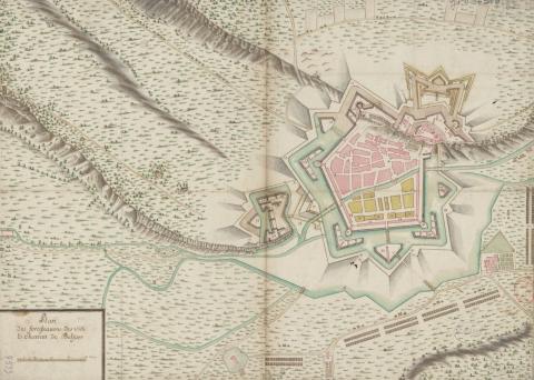
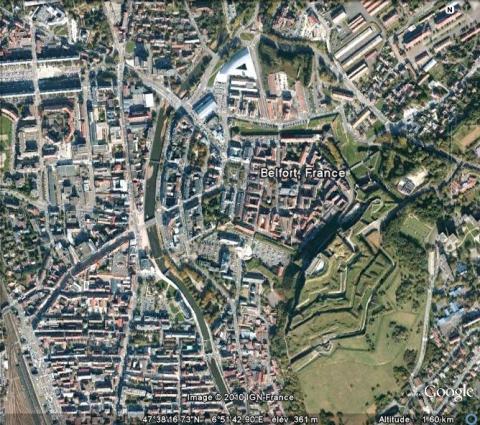
Medieval town, the origins of which can be traced back to the right bank of the Savoureuse, Belfort grew from a castle of the 11th century guarding the Belfort Gap, between the Jura and the south front of the Vosges. This castle was modernised multiple times until the town came into French hands under Louis XIV and Mazarin in 1648, following the treaties of Westfalia.Vauban got to work in Belfort in 1675, where he proceeded with construction work to modernise the urban wall. However, it was not until 1687 that he got to work on significant modification of the castle and the urban wall, to which he added five fortified towers with counterguards. Collectively, these works modified the route of the urban wall, which then became pentagonal, and slightly irregular at the level of the castle, which was transformed into a citadel. This regularisation of the route was also accompanied by an expansion of the perimeter of the urban wall, which would henceforth include multiple hectares of land situated on the left bank of the Savoureuse. He diverted the course of the Savoureuse, the river bisecting the town, in the aim of using the new course as a form of hydraulic defence to the west. Only one channel still runs through the town. He constructed barracks along the curtain walls and helped lay out the former city paths, while also creating new areas on the left bank of the river, which were subsequently included in the regularised urban wall. The houses concerned came into being in line with town-planning standards and were all of equivalent height and width. The new urban fabric was orthogonal. Underway from 1687, the construction continued during the years from 1690, only to be suspended on multiple occasions due to a lack of manpower. Finally completion came around 1703. Two projects remained unfinished however: an entrenched camp project abandoned to the north-east of the town, and that of a hornwork in front of the east bastion of the urban wall and flanked to the north of the castle.
Other work was carried out from 1816, after two Prussian sieges in 1813 and 1815. These reinforcements were also performed with the goal of replacing the razed Huningue. General Haxo completely modified the castle from 1830, which then saw it equipped with a vaulted barracks and a cavalier on two-stages of guns. Following the Prussian siege of 1871, the castle was restored and a belt of forts on the outskirts was constructed by the general Séré de Rivières.
Current state
Half of the fortified ramparts still remain, three fortified towers, the porte de Brisach and its ravelin, the coronation spot and the eastern moats, the fort and barracks of the castle and the hotel of the governor. These remains enjoy protection as an historic monument. They can be visited freely, with or without a guide – contact the appropriate local office for more information. A museum is also housed within the fort (or citadel). It retraces the military history of Belfort for the past two millennia. The tunnels can also be visited. To document the missing portions of the ramparts, have a look at the relief map of 1755 at a scale of 1/600, repaired in 1825 and preserved at the musée des Invalides in Paris.
Belfort
Belfort
47° 38' 17" N, 6° 51' 46" E
Type
urban wall, citadel, town planning
Engineers
Sébastien le Prestre de Vauban, François Nicolas Benoît Haxo, Raymond-Adolphe Séré de Rivières
Department
Territoire de Belfort
Region
Bourgogne-Franche-Comté
Bibliography
- GRESSET (M.), Vauban et la Franche-Comté, Saint-Léger-Vauban, 1996.
- KINTZ (J. P.), Belfort, forteresse royale, citadelle républicaine, Thionville, 1997.
- Ouvrage collectif, Vauban et ses successeurs dans le Territoire de Belfort, Paris, 1982.
- MARTIN (P.), La route des fortifications dans l’Est, Paris, 2007.
- PROST (P.), « L’apport de l’ingénieur François Nicolas Benoît Haxo à la fortification » in Un digne successeur de Vauban, François Nicolas Benoît Haxo (1774-1838), Belfort, 2001, p.65-69.
- SARRAZIN (G. & J.), Le Château de Belfort, Besançon, 1975.
- WARMOES (I.), Le Musée des Plans-Reliefs, Paris, 1997, p.43-44.

