Calais
History and description
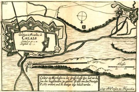
Calais, a town founded in the 10th century by the Counts of Flanders, saw its first urban fortifications built in the 12th-13th centuries. The west flank was protected in 1228, by a Philippian castle including a large detached tower. The urban wall was renovated in 1228 by Philippe Hurepel, count of Boulogne and son of the king of France Philippe II Auguste. The dimensions of the urban wall were thus 1,100 metres by 400, flanked by forty-four semi-circular towers, and including four gates, the latter of which preceded by pre-gates arranged on a circular embankment. Taken by the English in 1346, it became the English crown territory up until 1558, when it was recaptured by the Duke of Guise, on the orders of the King Henri II of France. During this English conquest, new defensive works were installed to control the pont de Nieulay to the west of the town, a bridge which was crucial to control the hydraulic defences. Other renovations were performed at Risban for the protection of the access channel to the sea. The urban wall was first adapted to accommodate artillery with the installation of new towers for cannons and the artillery boulevards. It was after the French recapture that the urban wall was fortified and King Francis II decided to construct a square citadel in 1560, which encircled the Philippian castle to the front. On this occasion, this work would see multiple districts of the town lost. The construction got underway in 1564, directed by Jean Errard of Bar-le-Duc. Under Henri IV of France, other construction drives were also launched on the urban wall of the citadel and that of the town and a chapel was constructed in the citadel. From 1630 to 1640, Louis XIII and Richelieu modified again the urban walls and the fort Nieulay and had a square arsenal constructed, wheat mills and bread ovens in the citadel. These constructions were directed by the engineer d’Argencourt.In 1658, Calais declined in strategic importance following the recapture of Gravelines by Louis XIV. Vauban, however, was given the task of modifying the site from 1677. His constructions included modifications made to the citadel, to the urban wall, to the fort Risban and to the fort-lock of Nieulay. This fort had been constructed in 1558 to protect locks of the flood defences of Calais. Vauban completely reconstructed it, placing it in the middle of a drainage channel with a wish to protect the locks by the urban wall of the fort. This new fort was rectangular with four angled bastions and two ravelins in the middle of the wider areas. The fort contained all the usual equipment for this kind of work: barracks, officers’ quarters, an arsenal, magazines, a cistern and a chapel. The Risban fort was subject to similar renovations. The citadel was modified by completely doing away with the medieval castle which had surrounded it in one of its bastions. This construction work ended around 1690. However, Vauban completed a final project of locks for Calais in 1704, during the war of Succession of Spain.
In the 19th century, the citadel housed a barracks with a thousand soldiers, two cisterns, powder kegs, food supplies and cattle sheds and a bomb shelter "Seré de Rivières" was added to it. During the Second World War, the bunkers of the Wall of the Atlantic were constructed by the Germans in the fort Nieulay.
Current state
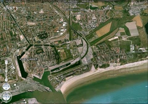
The fort Risban and the fort Nieulay still remain, although the latter had to be significantly restored after damage sustained in the Second World War. The ramparts of the Fort Nieulay and the external works, namely the earth redoubt known as des Salines, have been preserved, likewise the two water gates and the bridge-lock, but not the internal buildings destroyed under the Occupation. The two forts are classed as historical monuments and can be visited when contacting the tourist office. Also still standing is a sub-aerial cistern used for drinking water. Of the citadel, still standing are the urban walls and the gate on coast, the porte de Neptune, classed as a historical monument. The flooded ditches have also been preserved. The internal constructions of the citadel, as well as the majority of the superstructures of the ramparts and the urban wall itself, have vanished, razed to the ground during the Second World War and the reconstruction in the years 1940-50. The relief map of 1691 at a 1/600 scale, updated in 1833, is preserved in the musée des Beaux Arts (Fine Arts museum) of Lille.
Calais
Calais
50° 56' 53" N, 1° 51' 23" E
Type
urban wall, citadel, hydraulic defence
Engineers
Jean Errard de Bar-le-Duc, Pierre de Conti d’Argencourt, Sébastien le Prestre de Vauban
Department
Pas-de-Calais
Region
Hauts-de-France
Bibliography
- FAUCHERRE (N.), HANSCOTTE (F.), La route des villes fortes du Nord, Paris, 2003.
- LENOIR (L.), A la découverte des anciennes fortifications de Calais, s. l. n. d..
- LENOIR (J.-C et L), Risban d’hier et d’aujourd’hui, t. XVIII, 1998.
- WARMOES (I.), Les plans-reliefs des places fortes du Nord dans les collections du Musée des Beaux-Arts de Lille, Lille-Paris, 2006.

