Nice
History and description
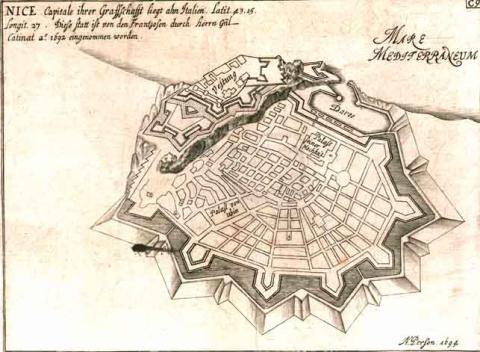
A town of ancient origin, Nice has been fortified since at least the middle Ages. In the 14th century, the area of the urban wall and the medieval castle peaked. When the county of Nice was connected to the Duchy of Savoy in 1388, the unhappiness of France fuelled border disputes that would last multiple centuries and which remained unresolved until 1860 and the annexion to France under Napoléon III. In the 15th century, in this context, the Savoy governor Nicod de Menthon remodelled the castle from 1437, but these changes proved insufficient based on progress made in artillery. Duke Charles II of Savoy ordered the construction of the first modern fortifications from 1517. The architect André Bergante de Vervua thus constructed three bastions or bastioned towers, (known as Saint-Charles, Saint-Victor and Saint-Paul) around the castle, which then became a citadel. These initial works were still quite rounded. The constructions involved were transitory in nature. The defensive system was perfected between 1560 and 1580 by the engineers Bocero, Paciotto and Vitelli, on the orders of Emmanuel-Philibert I of Savoy. A hornwork comprising two orillon bastions was built in front of the tour Saint-Victor and the tour Saint-Paul, and the castle curtain walls were lowered. The urban wall of the town was transformed from 1543 based on the same objective. The route approached the sea to the south and then continued towards Paillon in the north, thus covering a larger area. Six orillon bastions were constructed along this new urban wall. Their construction was completed in around 1610. In 1556, the fort du Mont-Alban was planned to gain control of the high ground overlooking Nice and the peak connecting the latter to Villefranche-sur-Mer. Due to lack of funds, the completed fort was smaller than had been originally planned. It formed a square, each side of which was 45 metres with four angled bastions. The bastions were equipped with a capital basin and casemates to accommodate the soldiers. Entry was via a spiralling staircase following by a drawbridge installed in the eastern front. The 17th century saw several further additions made as last improvements. The citadel had three advanced lunettes installed (two in front of the hornwork, those of Sainte-Croix and Saint-Jacques; the third protecting the access road, which was called Saint-Jean) and a covered walkway. The urban wall also saw the addition of two orillon bastions to cover the porte Pairolière (Sainte-Christine bastion) and the porte Marine. Cardinal Maurice de Savoy, governor of the town and the county of Nice, ordered this construction in 1677.Vauban visited Nice for the first time in 1693, two years after it had been captured by the French during the War of the League of Augsbourg. He favoured retaining and improving the Nice fortifications instead of destroying them, and this was also the advice he gave in 1706 during the War of Succession of Spain. His partner, Niquet, designed an improvement project in 1692, targeting this objective. Louis XIV did not take any heed at all of these two projects and destroyed Nice. The first demolition commenced in 1691 but was abandoned and those from Savoy restored the stronghold after 1696. In 1705, after their defeat in Turin, the French recaptured Nice and recommenced its demolition. A public offer of property improvement was implemented in 1706 to follow the demolition of constructions which was completed around 1715-1723. During this period, the fort Mont-Alban suffered no modification.
In the course of the 18th-19th centuries, the fortifications of Nice were not reconstructed. It was not until the Third Republic that the General Sérés de Rivière would construct frontier forts in the area. André Maginot thus incorporated Nice in the alpine Maginot Line in the period between two wars.
Current state
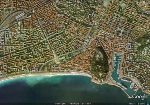
There is no remaining trace of the fortifications of Nice. New districts, avenues and a railway station occupy the sites where they once stood. The rock of the citadel had been transformed into a city park. The fort Mont-Alban, completely preserved, is in the process of being ceded to the town of Nice.
Nice
Nice
43° 41' 56" N, 7° 16' 17" E
Type
urban wall, citadel and detached fort
Engineers
André Bergante de Vervua, Boiero, Francesco Paciotto, Ferrante Vitelli, Sébastien le Prestre de Vauban, Raymond-Adolphe Séré de Rivières
Department
Alpes Maritimes
Region
Provence-Alpes-Côte d'Azur
Bibliography
- ADGE (M.), CATARINA (D.), CROS (B.) PASSET (C.) et RIBIERE (H.), La route des fortifications en Méditerranée, Paris, 2007.
- COSTAMAGNA (H.), « Nice : ses remparts et son château » in Vauban et ses successeurs dans les Alpes maritimes, Paris, 2004, p.45-59.
- LETTRE (B.), « Le fort du Mont-Alban » in Vauban et ses successeurs dans les Alpes maritimes, Paris, 2004, p.153-156.

