Perpignan
History and description
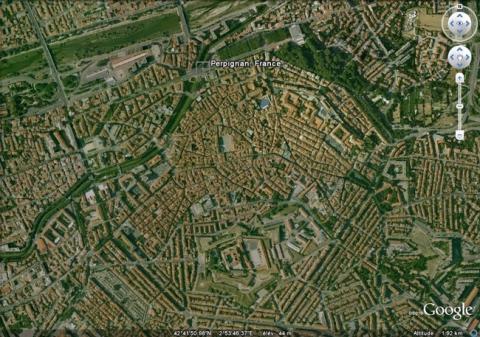
Founded on a strategic site since Antiquity, Perpignan became the residence of the Counts of Roussillon at the end of the 10th century. It was also during this period that its first fortifications were built in the form of a primitive Cellera, very rapidly replaced by an initial urban wall, of which nothing remains today. The second urban wall was constructed by the Kings de Majorca at the end of the 13th century. The perimeter was enlarged and it was equipped with thirty towers and ten gates. Occupied by the armies of the King of France Louis XI from 1463 to 1473 and then from 1475 to 1495, the town was restored to Aragon and became a forward stronghold of this kingdom and then of the unified Spain, against France. The first citadel was constructed under the French occupation on the current site. From 1555, Perpignan had its first modern works: six bastions and two ravelins were constructed in front of the urban wall by the Spanish engineer Juan Bautista Calvi. The citadel was also equipped with ravelins. This initial construction was completed in 1577 but others followed in the 16th and 17th centuries until the town was captured by the armies of Louis XIII in 1642, a capture which was definitively confirmed by the Treaty of the Pyrenees of 1659. Errard de la Marck worked there around 1600.Following the annexing of French Catalonia, Vauban and Saint-Hilaire created a first project for Perpignan in March 1669, following the War of Devolution. This project was not implemented but the second project, drawn up in spring 1679 after the War of Holland, retained its principles and added details concerning the watchtowers and guardroom, which were not included in the original plan. This construction was the largest by Vauban in the region: the Spanish bastions were expanded and others were created. Moats were dug and ravelins and parade grounds were constructed in front of them. Glacis preceded the defensive installation. The citadel was completely remodelled and transformed into a slightly irregular hexagonal fortress with six bastions. Five new ravelins completed those of the Spanish. The parade ground of the citadel was remodelled and new barracks constructed around it. The construction was terminated in 1684. A project involving a new town, designed at the same time to accommodate a greater number within expanded ramparts and relocate those residents having been displaced by an extension of the esplanade of the citadel, was drawn up in 1699 by the engineer Rousselot but not implemented until 1860, under the Second Empire.
In 1885, the fort de Serrat d’en Vaquer was constructed to the South of the town to boost the protection of this coast. This was a fort of the type favoured by Séré de Rivières.
Current state
The citadel still stands and is still occupied by the army. It is not open to the public. It is in a good state of preservation, only the external defences and moats have disappeared. The urban wall was downgraded in 1901 and demolished between 1904 and 1930 to be replaced by urban avenues. All that remains is the Saint James bastion and a medieval wall, the towers of which were redeveloped into residences. The Castillet is one remaining part. The barracks of the 17th century are also worthy of mention, near to the Saint James bastion, and having been converted into social lodging. The fort Serrat d’en Vaquer is well preserved and open to the public. To document the extent of the ramparts, the best documentary reference is the relief map at a scale of 1/600, constructed in 1701 and preserved at the museum of Relief Maps in Paris.
Perpignan
Perpignan
42° 41' 55" N, 2° 53' 44" E
Type
urban wall and citadel
Engineers
Juan Batista Calvi, Sébastien le Prestre de Vauban, Jacques de Borelly de Saint- Hilaire, Christophe Rousselot
Department
Pyrénées-Orientales
Region
Occitanie
Bibliography
- AYATS (A.), Les fortifications de Vauban, Découverte guidée en pays catalan, Canet, 2005.
- DE ROUX (A.), Villes neuves, urbanisme classique, Paris, 1997.
- DE ROUX (A.), Perpignan, de la place forte à la ville ouverte Xe-XXe siècles, Perpignan, 1999.
- FAUCHERRE (N.), La route des fortifications en Méditerranée, Paris, 2007.
- WARMOES (I.), Le musée des Plans Reliefs, Paris, 1997, p.54.
![Perpignan, plan de 1693, dans Recueil des plans des environs de plusieurs places du Royaume faits en l’an 1693, [Paris], pl. 39, gallica.bnf.fr / Bibliothèque nationale de France. Perpignan, plan de 1693, dans Recueil des plans des environs de plusieurs places du Royaume faits en l’an 1693, [Paris], pl. 39, gallica.bnf.fr / Bibliothèque nationale de France.](/sites/default/files/styles/paragraphe_libre/public/images/plan_ancien-54.jpg?itok=_M1_s-po)
