Fort Sainte-Marguerite
History and description
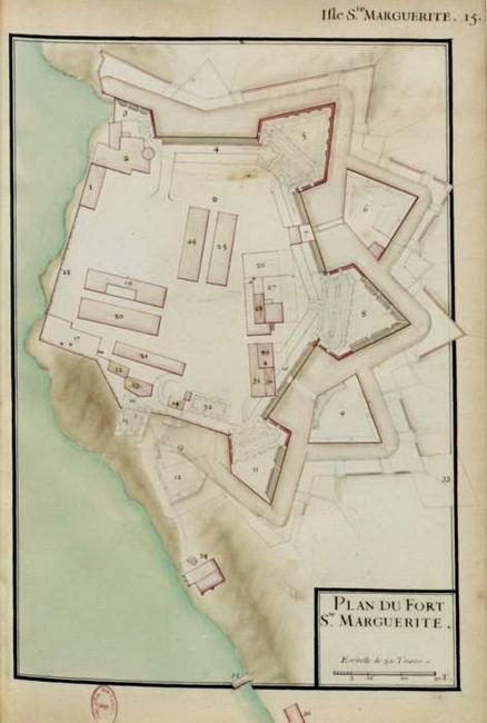
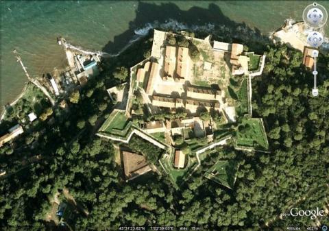
Situated on the île de Lérins, facing the town of Cannes, the site of the fort Sainte-Marguerite has been a strategic hub since the Antiquity (some foundations of a Roman fort were found). A medieval castle replaced this initial fortification and has survived until the 16th century. In July 1524, the Spanish landed there for the first time and blocked the port of Cannes. They returned on 14 September, 1535, and used the site to construct a crenelated wall and new fortifications around the primitive castle. This construction was still incomplete however, when the Spanish gave the isle to the French. In 1635 they recaptured the isle during the Thirty Years war and restarted construction. However, it was not until 1637 that Louis XIII and Richelieu ordered the completion of the fort Sainte-Marguerite, having recaptured the îles de Lérins.In 1682, during his first trip to Provence, Vauban proceeded with the modifications applied by the engineer Niquet, general engineer for the fortifications of the Dauphiné, Languedoc and Provence. The covered way was refurbished, likewise the ravelins and counterscarps. Following all this construction, the fort Sainte-Marguerite took on its current form: that of a bastioned irregular pentagon equipped with three fronts on the landward side. The latter included two bastions, two demi-bastions on the angles with the sea, two ravelins, dry moats, incoming parade grounds and an outgoing parade grounds, a counterscarp and a covered way with traverses. Two gates allowed access: the porte Marine to the west protected by a projection, and a gate in the south-east front, the porte Royale. The sea front is nothing but a wall without other defensive elements. Inside, four barracks (Saint-Hilaire, Saint-Honorat, Saint-Macaire and Saint-Urbain) were constructed based on the plans of Vauban. The scope also included a well, the governor’s residence, the residences of engineers, the priest, the major, artillery magazines, a chapel and a bakery. The main powder keg was situated in the south bastion, known as the bastion Royal. Grouped around the parade ground and all possessing identical proportions, the barracks bore the stamp of Vauban as the first attempt of the plan type for this kind of building. In 1846, the fort de la Convention was constructed to the east of the fort Sainte-Marguerite, which was definitively reclassified as a prison, something it had already become since 1680 when the Iron Mask, among others, was held there. Other defensive works were constructed on the isle during 1930 by the French army to defend Cannes against an Italian attack.
Current state
The fort Sainte-Marguerite still exists and is open to visitors. Only the chapel was destroyed in 1944 during the allied bombardments preparing the Provence landing. The fortifications and certain interior buildings have been overrun by vegetation. In response, the Association of Young People of Provence-Alpes-Côte d’Azur organises annual volunteer placements for the securing and restoration of the fort buildings. The fort and isle are classed as a historic monument and site. The relief map at a scale of 1/200 (scale of the fort 1/175e), constructed in 1728 and restored in 1816 and 1920, is on show at the museum of Relief Maps in Paris.
Fort de Sainte-Marguerite
Fort de Sainte-Marguerite
43° 52' 35" N, 7° 4' 46" E
Type
fort
Engineers
Sébastien le Prestre de Vauban, Antoine Niquet
Department
Alpes Maritimes
Region
Provence-Alpes-Côte d'Azur
Bibliography
- ADGE (M.), CATARINA (D.), CROSS (B.) PASSET (C.) et RIBIERE (H.), La route des fortifications en Méditerranée, Paris, 2007.
- RIBIERE (H.), « Le fort Royal de Cannes » in Vauban et ses successeurs dans les Alpes maritimes, Paris, 2004, p.111-119.
- Site internet du Ministère de la Défense, Chemin de mémoire : http://www.cheminsdememoire.gouv.fr/fr/le-fort-royal-de-lile-sainte-marguerite
- WARMOES (I.), Le Musée des Plans-Reliefs, Paris, 1997, p.50.

