Montmédy
History and description
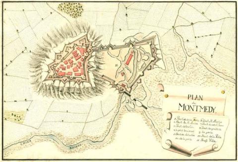
An agglomeration of medieval origin, the site of Montmédy had its first fortifications built in 1221 when Count Arnould III de Chiny constructed a castle there on the rocky headland dominating the course of the Chier stream. Between 1222 and 1235, a urban wall surrounded the Upper Town (Ville Haute) to complete the defensive set-up. From 1544, Charles Quint replaced this castle fort and surrounded the Upper Town (which was known as a fortress in a slightly misleading way) with bastioned ramparts. The latter included eight bastions. The Low Town (Ville Basse) had been without any ramparts up to this point. Subsequently, construction on the Upper Town continued up until 1652. The maison du Gouverneur (Governor’s house) was constructed during this period, on the site of the medieval castle, which disappeared.Captured by France in 1657, under a siege directed by Vauban and one in which he was injured four times, Montmédy was linked to the France of Louis XIV by the treaty of the Pyrenees two years later. In 1681, Vauban surrounded the Low Town with an urban wall including seven bastions, five ravelins and three gates. This urban wall was connected to that of the Upper Town. During this construction, he modified the ramparts of the Upper Town by the addition of an external covered way to the moats and added barracks as well as military buildings crucial to the smooth running of a fort (powder kegs, etc.). The barracks were set up on former adjoining gardens of the maison du Gouverneur. Artillery casemates were installed in the moats under the front of the bastion Connils and bastion Saint-André. In 1698, his focus switched to the Upper Town, the ramparts of which were elevated and the moats deepened. Passages were added to the covered walkway and the demi-lune des Porcs (ravelin of the Porks) was carved in stone, the parapets were elevated and the incoming and outgoing parade grounds were expanded. The false ramparts were modified to handle low fire. This final phase of construction did not take place until after 1707.
The successors to Vauban reinforced the covered way of the Upper Town and added traverses. The barracks of the Upper Town were also refurbished. The église Saint-Martin (Saint-Martin church) was reconstructed in 1753. After 1870, General Séré de Rivières remodelled the Upper Town by constructing a tunnelled casemated barracks there, breadmaking ovens and multiple casemates.
Current state
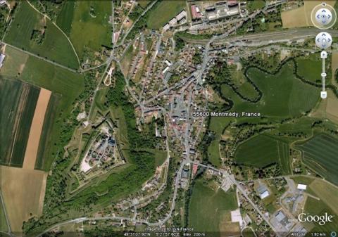
The ramparts of the Upper Town of Montmédy still remain completely intact. Today, minimum maintenance is ensured by the mowing of the grass of the moats and cutting down any obstructing trees. The urban wall of the Low Town was demolished, with nothing remaining except a few walls and two echauguettes. All these elements can be visited and represent a city park.
Montmédy
Montmédy
49° 31' 13" N, 5° 22' E
Type
urban wall
Engineers
Sébastien le Prestre de Vauban
Department
Meuse
Region
Grand Est
Bibliography
- CADY (G.), TOUSSAINT (C.), La place forte de Montmédy. Promenades du patrimoine en pays de Montmédy, Virton, 2006.
- DE WAHA (G.), Le fidèle et vaillant gouverneur Jean d’Allamont. Nouvelle édition présentée et annotée par Daniel Garrot, augmentée de divers documents concernant le siège de Montmédy de 1657, Saint-Mard, 1999.
- GABER, Lorraine, la route des fortifications, Metz, 1999.
- MARTIN (P.), La route des fortifications dans l’Est, Paris, 2007.
- Ouvrage collectif, Vauban, sa vie, son œuvre, Saint-Léger-Vauban, 1998, p. 61.

