Neuf-Brisach
History and description
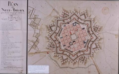
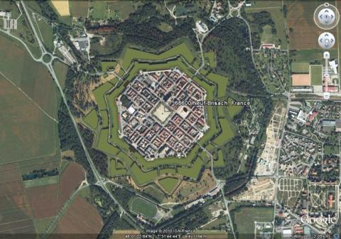
Neuf-Brisach is one of the new towns created from scratch by Vauban. Its construction was intended to compensate for the loss of the fortified town of Breisach-am-Rhein, situated on the right bank of the Rhine and controlling the mouth of the same. Vauban had already been active in the area, having created the urban wall and the city extension of Breisach-am-Rhein between 1664 and 1670, captured by the French in 1639 during the Thirty Years war. The Treaty of Rijswick of 1697 compelled France to return the Baden area to Austria and to demolish everything that had been constructed there, a loss which left a hole in the defence of Alsace between Huningue and Strasbourg.Mandated by Louis XIV from 1697, Vauban selected the site of Neuf-Brisach due to its proximity to Brisach, while remaining outside the scope of the same. He submitted three projects to Louis XIV, who selected the most extensive and expensive option. This project involved the construction of fortified octagonal town, equipped with a double urban wall: initially a safety wall, equipped with curtain walls and bastioned towers with echauguettes, followed by a combat wall, which included detached bastions, large tenailles, ravelins – four of which with inner fortified structures and four without, a covered way with traverses and refurbished counterscarp, and a large glacis. A crownwork comprising two fronts was also included before the north-east front. Four gates were also included in the urban wall: Belfort, Colmar, Strasbourg and Basel. These gates included fixed bridges, then drawbridges, experimental casemates, portcullis and a guardroom. Inside, a garrison town with an orthogonal design and a central parade ground were constructed. The central military buildings were the Governor’s residence, the town hall, the house of the major, that of the king’s lieutenant, the commissary and the intendant, the arsenal and the halls. The houses of the engineers, officers and various magazines were distributed among the various urban islets, among the civilian houses. The barracks were placed along the ramparts. The houses were equipped with additional bedrooms to accommodate reinforcements and vaulted cellars serving as anti-bombardment shelters. Four public wells were dug at each angle of the central parade ground.
Construction got underway from 1698 with a series of earthworks. The engineer Tarade, head of the Alsace fortifications, oversaw the operation, deputised by the contractor Jean-Baptiste de Regemorte. Two canals were dug to transport heavy stones from the Vosges, some thirty kilometres away and the rubble of the French constructions of Breisach-am-Rhein demolished at the same time, which would be used for the purpose of blockage. From 1699 to 1700, work on the stone construction continued until it was finished at the end of the latter year, whereupon Neuf-Brisach was declared ready to be defended. The town-planning started with the military buildings but slowed after 1703 and the recapture of Breisach-am-Rhein by the French during the war of Succession of Spain (the final siege arranged by Vauban). The crownwork of the north-east was never completed. The porte de Belfort also remained incomplete, lacking a fixed bridge.
After 1871, the Prussians elevated the parapets and corrected the fault which had allowed them to bombard the town with rifled bores. The drawbridges were replaced by fixed bridges and two out of four gates lost their superstructures.
Current state
The entire protective wall still stands and has been redesigned as an area for walking, which is regularly maintained. Apart from the Prussian modifications mentioned above, nothing else was changed. Henceforth, the incomplete porte de Belfort has been used to house a museum dedicated to the work of Vauban. Almost all the internal constructions have disappeared, falling victim to bombardments of 1870-1871 and 1944-1945. All that is left is the Governor’s residence, the église Saint-Louis (Saint-Louis church), the town hall, the arsenal, the house of lieutenants and the halls. The town outline has been preserved. The town and its urban wall have also been included on the List of World Heritage as part of the fortifications of Vauban. Projects of cross-border promotion were established with Breisach-am-Rhein and the entire area gave rise to projects involving touristic development. The relief map at a scale of 1/600, constructed in 1706 and restored in 1782, is preserved at the musée des Plans reliefs (relief Maps museum) but not in show. A copy can be seen at the musée Vauban in Neuf-Brisach.
Neuf-Brisach
Neuf-Brisach
48° 1' 8" N, 7° 31' 45" E
Type
new town and town planning
Engineers
Sébastien le Prestre de Vauban, Jacques Tarade
Department
Haut-Rhin
Region
Grand Est
Bibliography
- COUTENCEAU (I.), « Neuf-Brisach (1698-1705), la construction d’une place forte au début du XVIIIe siècle » in Revue historique des armées, s. l., 1988, n°13891, p. 16-21.
- HALTER (A.), Histoire de la place forte de Neuf-Brisach, Strasbourg, 1962.
- HALTER (A.), Le chef d’œuvre inachevé de Vauban, Neuf-Brisach, Strasbourg, 1992.
- JORDAN (B.), MENGUS (S.), Dossier d’inventaire préliminaire préétabli sur Neuf-Brisach, s. l., 1999.
- MARTIN (P.), La route des fortifications dans l’Est, Paris, 2007.
- MONGIN (M.), STEENBERGEN (M.), Neuf-Brisach, la ville idéale, Woippy, 2013.
- Ouvrage collectif, Vauban, sa vie, son œuvre, Saint-Léger-Vauban, 1998, p. 64-66.
- PONSOT (P.), Etude préliminaire relative à la restauration de l’ensemble des remparts de Neuf-Brisach, Blois, 1993.
- WARMOES (I.), Le Musée des Plans-Reliefs, Paris, 1997, p.43.

