Strasbourg
History and description
In the Alsace plain, on the left bank of the Rhine, where it meets the Ill and Bruche, rivers from the Vosges, Strasbourg came into being during the Antiquity. A fort constructed by the Romans in around 12 BC to puncture the Limes of Germany, named Argentoratum, would be the precursor to the agglomeration. Pillaged and razed to the ground twice during the Late Antiquity, in 352 by the Alamans and 451 by the Huns, the town recovered under the Franks in the 6th century, when it had the name Strateburgum. Under the Carolingians, it became a significant town (the sermons of Strasbourg were stated there by Charles the Bold and Louis II the Germanic in 842). Integrated into the Carolingian kingdom of Germany, Strasbourg became a significant town of the Germanic empire from the 10th century.The first fortifications of wood and earth were replaced from the 12th century by an urban wall constructed including eighty towers. This urban wall was expanded in the 14th century with the population growth. The first modern military works were constructed from 1564 by the engineer Daniel Specklin, during the Religious wars of the 16th century. The urban medieval wall was endowed with bastions and glacis. Its perimeter was twelve kilometres and the military properties covered one hundred and twenty hectares of land. During the Thirty Years war, Strasbourg was not besieged and remained German following the treaties of Westphalia from 1648. In 1678, the Treaty of Nijmegen drove the Holy Empire to cede the town to France, but it resisted. It took a siege conducted by Louis XIV in person for Strasbourg to become French in 1681.
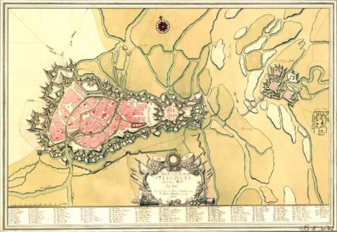
After having captured the town, Vauban established a significant project of improving the fortifications of this place, which was very important for the defence of Alsace. He designed the map of a pentagonal citadel, equipped with five bastions, five ravelins with inner fortified structures, two hornworks (to the north, and east), flood defences and usual internal buildings for this type of fortification (chapel, barracks, etc.). It was equipped with two gates, to the south-west and south-east respectively. An esplanade which covered a large area separated the citadel from the old town. For the urban fortifications, the ramparts created by Specklin were improved by adding hornworks, counterguards and bridge-locks intended to be installed as part of the flood defences, mainly supplied by the Ill. The larger defence was situated to the south. A vast pond covering several dozen hectares could be maintained in front of the glacis in a marshy area. Barracks and military hospitals were constructed in the town. External works were added to the isles of the Rhine: a square fort with four bastions, four ravelins and a gate to the south. This fort, called fort de Kehl, was surrounded by a glacis and flooded moats. Two hornworks and a lunette, separated from the fort by an arm of the Rhine, flanked it to the east, north-east and north. This fort controlled, with the citadel, the mouth and bridges of the Rhine towards Germany. The engineer Tarade, head of the fortifications of Alsace, directed the construction on-site and applied the project of Vauban, which continued up until 1698. The result of this construction can be seen by examining the first relief map of Strasbourg, created in 1725-1728 at a scale of 1/600, seized by the Prussians in 1815 and given to the town by the German emperor Guillaume I. This relief map indicated the state of the stronghold at the start of the reign of Louis XV, before the modifications completed by Louis de Cormontaigne. These modifications were minimal. He notably demolished the two hornworks of the citadel, to replace them by only one situated to the east, larger and designed for artillery. The relief map reveals information on the extent of the area of military easement which had increased since 1680: eighteen kilometres long and four hundred and two hectares.
In the 19th century, the fortifications of Strasbourg were modified to a slightly greater extent than under Louis XV, under the July Monarchy, the Second Republic and the Second Empire. While the plotted ramparts and citadel were not modified by the report to 1734, their area was reduced by a rectification of the plotted area and doing away with the external defensive works (the area of military properties was reduced to two hundred and fifty eight hectares and the perimeter fell to fourteen kilometres). The fortifications established on the isles of the Rhine disappeared, following the channelling and correction of the river between the years 1857 and 1863. The cause of this disappearance was due to the small isles and tributaries which had been built on becoming dried out and filled in. Multiple marshy areas, which were used for the defence of the town, were drained with the construction of new dikes and canals between the Rhine and the Ill, as well as the creation of the inland port and the digging of the canal from the Marne to the Rhine. In 1852, the arrival of the railway at Strasbourg did not prompt any modifications of the defensive system since the Paris-Strasbourg line was routed in the glacis between the ancient works and was completed over the end, once the defensive wall of the corps de place had been crossed. The Strasbourg-Kehl line bypassed the town to the south. The hydraulic defences were not significantly modified, except for installing new bridge-locks. All these modifications were documented by the second relief map of Strasbourg, created to a scale of 1/600 in 1836, and updated between 1857 and 1863.
Annexed to Germany in 1871, Strasbourg had new military construction from 1872, directed by Prussian generals Von Moltke and Von Kameke. These constructions aimed to transform the town into an entrenched camp via a belt of peripheral forts, situated around ten kilometres away from the agglomeration and included in a perimeter of thirty-five kilometres around it, on either side of the Rhine. Completed in 1876, the forts were modernised between 1885 and 1893 to adapt to the torpedo shells. Between 1937 and 1940, the French added concrete works and included Strasbourg in the Maginot Line.
Current state
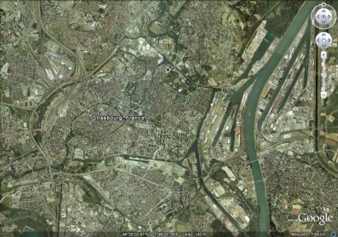
The urban wall and the citadel, seriously damaged by the Prussian siege of 1870, were razed under the German Empire, in 1870 and 1880. Urban avenues and new districts have replaced the emplacements. Only one front of the citadel has survived, integrated into a city park, and four medieval towers. The Governor’s residence and a military hospital also remain. Urban visit tours, guided or unaccompanied, are available. However, to reconstruct the extent of these fortifications, the best documents are the two relief maps cited above. In tandem with engraved or manuscript maps, they illustrate two successive states of defences for the Alsatian town. Neither of the two is on show however. That from 1725 is preserved at the History museum of Strasbourg, sealed since 1990. The relief map from 1836 is preserved in the reserves of the musée des Plans Reliefs (museum of Relief Maps) in Paris.
Strasbourg
Strasbourg
48° 34' 24" N, 7° 45' 8" E
Type
citadel, urban wall and hydraulic defence
Engineers
Daniel Specklin, Sébastien le Prestre de Vauban, Jacques Tarade
Department
Bas-Rhin
Region
Grand Est
Bibliography
- « Strassburg. Die Geschichte seiner Befestigungen » in Fortifikation. Fachblatt des Studienkreises für Internationales Festungs, Militar und Schutzbauwesen e.V., s.3, Saarbrücken, Interfest, 1998, in n°4.
- HATT (T.), Comparaison des plans reliefs de 1725-1728 et 1836-1863 à Strasbourg, dans L’aménagement paysager des fortifications bastionnées, Longwy, 2008, (actes de colloque organisé par le Réseau des Sites majeurs de Vauban).
- MARTIN (P.), La route des fortifications dans l’Est, Paris, 2007.
- WARMOES (I.), Le Musée des Plans-Reliefs, Paris, 1997, p.43.

