Toul
History and description
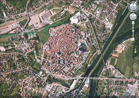
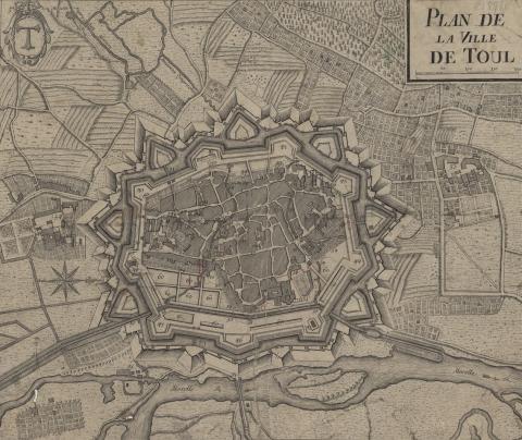
A town of Gallo-Roman origin (Tullum), situated on a confluent of the Moselle and the Ingressin, Toul had its first fortifications built in 375. This urban wall was largely replaced in the middle Ages by another, made of stone, on a very irregular route which resisted multiple French or imperial sieges and survived up until 1689. This urban wall was partially modernised in the 17th century by the addition of three ravelins and was destroyed in 1689, with the outbreak of the war of the League of Augsbourg.In 1698, Vauban designed an initial project for Toul. It involved rebuilding the destroyed ramparts while also improving them. The aspect of the stronghold was also totally modified by the demolition of the former walls, the filling in of their moats and the creation of a new bastioned urban wall. This was a regular nonagon with nine bastions, seven ravelins, three gates, dry moats, a glacis and a canal bordered with trees along the Moselle. This new urban wall allowed the usable area inside to be increased. Barracks were built along the curtain walls and a Governor’s Residence was constructed in the town. In 1700, Vauban established his second project to plot the interior of this new urban wall. The emplacements exposed by the medieval ramparts were transformed into urban islets according to a checkerboard pattern, the streets were corrected and paved. A new district was constructed around a square and an avenue leading to the porte de France. Two esplanades were also built near the porte de France.
However, the projects of Vauban remained incomplete. The decoration of the counterscarp only took place in the 19th century and only three of the ravelins were built. The 19th century saw the decoration of the escarps replaced, damaged after the Prussian siege of 1815. In 1872-1874, Séré de Rivières constructed a belt of peripheral forts around the town.
Current state
All the fortifications of Toul have been preserved. Only two gates were enlarged to allow road traffic to pass through. The Governor’s residence has also survived. The fortifications of the 17th century, which today constitute a city park, as well as the vestiges of the Gallo-Roman ramparts, are classed as historical monuments. The relief map, on a scale of 1/600, constructed in 1861 and restored in 1966, is preserved at the musée des Plans Reliefs (museum of Relief Maps) in Paris but not on show.
Toul
Toul
48° 40' 30" N, 5° 53' 30" E
Type
urban wall and town planning
Engineers
Sébastien le Prestre de Vauban, Raymond-Adolphe Séré de Rivières
Department
Moselle
Region
Grand Est
Bibliography
- DE ROUX (A.), Villes neuves, urbanisme classique, Paris, 1997.
- GABER (S.), Lorraine, La route des fortifications, Metz, 1999.
- MARTIN (P.), La route des fortifications dans l’Est, Paris, 2007.
- WARMOES (I.), Le Musée des Plans-Reliefs, Paris, 1997, p.41.

