Verdun
History and description
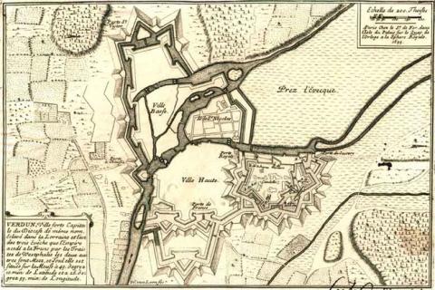
Situated along the Haute Meuse and with its own bishop since the 3rd century, Verdun has been a fortified agglomeration since the time of the Merovingians. Taken initially by Henri II of France in 1552, the town was besieged several times during the following century before finally becoming a permanent part of France of Mazarin under the treaties of Westphalia in 1648. However, from 1559, the town occupied by the France had its first modern constructions with the construction of the pentagonal citadel on the colline Saint-Vannes (Saint-Vannes hill), which dominated the town. The urban wall remained however, from the middle Ages. In 1624, Louis XIII tasked Sublet de Noyers with fortifying the whole town. The construction work for the same was therefore passed on to the engineers Frédence and Conti d’Argencourt. In 1640, Jean Errard de Bar-le-Duc worked on modifications by remodelling the citadel, which he completed with the external section and ravelins, as well as countermines. However the construction remained incomplete when Vauban visited in 1663.Accordingly, Vauban decided to gather together the various projects of his predecessors by creating a totally new and bastioned urban wall. The defences of this urban wall were completed with hydraulic works allowing the creation of flood defences. The construction started in 1664 and continued up until 1692. The financial difficulties caused by the war of the League of Augsbourg put an end to this. Following this construction, the town was totally enclosed in a bastioned urban wall. The north and east fronts included arrow-headed bastions (certain of which also had medieval towers), preceded by ravelins and a hornwork in front of the Saint-Victor district. This latter work was reinforced with advanced ravelins and a network of countermines. To the south, the main defences were hydraulic: a flooded section of 2000 m long, 800 m wide and 2.50 m deep, could be maintained in front of the ramparts. In order to complete the set, three locks (Saint-Airy, Saint-Nicolas and Saint-Amand) were installed between 1680 and 1685, completed by several dams and canals, intended to fill the moats. New and spacious barracks were constructed in the citadel. The église Saint-Amand (Saint-Amand church) was also constructed based on the plans of Vauban.
Verdun changed very little over the 19th century. The construction commissioned by Vauban was simply completed. A barracks built on a test basis, the caserne Beaurepaire, was constructed in the citadel in 1833-1835. From 1874, peripheral forts of the “Séré de Rivières “style were constructed around the town. The most well-known of these were those of Douaumont and Souville, theatres of the battle of Verdun in 1916.
However, the ramparts and the citadel of the Ancient Regime were preserved and also experienced fierce combat. The citadel remained in military use and was also landscaped with new features, like the underground magazine situated behind the curtain wall of the bastion du Roi and the bastion de la Reine. Casemates were also improved and the shooting tunnels modernised. A significant network of tunnels, designed to shelter the entire garrison of the citadel, was also upgraded.
Current state
The citadel was preserved, as well as its interior buildings, and was rescued from the combat of the First World War. The entire facility is open to the public. However, the majority of buildings of this citadel were abandoned, in ruins and inaccessible. Part of the urban wall has survived to the south of the town and was integrated in a city park. The pont écluse de Saint-Amand (bridge-lock of Saint-Amand) has also survived, likewise four gates of the urban wall. This bridge-lock is the only example of a unit of which the machinery has also been preserved (winches and sliding panels). The other bridge-lock, namely that of Saint-Airy, has lost its machinery. The ruins of the forts of Douaumont and Souville are preserved as a memory of the First World War. The relief map of the town at a scale of 1/600, constructed in 1848-1856, and restored in 1920 and 1956, is preserved at the musée des Plans reliefs (museum of Relief Maps) in Paris without being on show.
Verdun
Verdun
49° 9' 32.1401" N, 5° 23' 12.2197" E
Type
citadel, urban wall and flood defences
Engineers
Frédence, Pierre de Conti d’Argencourt, Jean Errard de Bar-le-Duc, Sébastien le Prestre de Vauban, Raymond-Adolphe Séré de Rivières
Department
Meuse
Region
Grand Est
Bibliography
- DENIZOT (A.), Verdun et ses champs de bataille, Paris, 1998.
- GABER (S.), Lorraine, la route des fortifications, Metz, 1999.
- LE HALLE (G.), Verdun, ma ville, Amiens, 1992.
- MARTIN (P.), La route des fortifications dans l’Est, Paris, 2007.
- Ouvrage Collectif, Vauban, sa vie, son œuvre, Saint-Léger-Vauban, 1998.
- PEDRONCINI (G.), De l’oppidum à l’enfouissement. L’art de la fortification à Verdun et sur les marches de l’Est, Verdun, 1996, (Actes du colloque tenu à Verdun les 19, 20 et 21 mai 1995).

