Lille
History and description
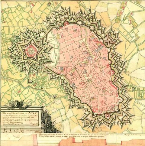
Coming into existence along a meandering stretch of the Deűle, a tributary of the Escaut, references to Lille date back to 1066. Found here, therefore, is a town with a castle, a collegiate church and a market. During the 12th-13th centuries, it became one of the capitals of the County of Flanders and was given an urban wall in around the 14th century. The 15th century saw the reinforcement of the curtain wall sections of this protective wall with avenues. The first modern works were constructed in 1603-1605 by the engineer from the Spanish Netherlands Mathieu Bollin. This came in the form of three western bastions namely Calvaire, Picquerie and Molinel. Seven others were also added to the east. Their faces were seventy metres long and their sides were twenty to thirty metres. They covered defensive lines which were two hundred to two hundred and thirty metres long. These initial modern works were not enough to stop Louis XIV from personally taking control of the town on 28 August, 1667, after a siege of ten days. In 1668, via the treaty of Aix-la-Chapelle, Lille became French and was integrated in the first line of the Pré Carré ten years later.From the month of September 1667, Louis XIV decided on the construction of the citadel. Vauban, played off against the Knight of Clerville, was commissioned with its construction on 15 October, 1667. The earthworks commenced in December and were completed with the laying of the first stone on 17 June, 1668. The construction of the ramparts and glacis were completed in 1670 but that of the internal buildings was not finished until between 1672 and 1673. The choice of site was dictated by the topohydrography: the presence of marshes rendered the approach work in the event of a siege more difficult than elsewhere. The enemy was thus obliged to besiege first the town, then the citadel via the two fronts turned towards the town. This citadel is a perfect pentagon with five royal bastions (namely: each flank 49 metres, each face 87 metres long and 240 metres long for the defensive lines). The five fronts were equipped with low outlines, flood plain ditches forty metres wide, five ravinels, multiple crenelated inner fortified structures, a counterscarp covered way and four gates. The most famous of them, on one of the fronts of the town, was the Porte Royale, which was equipped with a frontispiece supported by Doric columns and a square of trophies for arms of France and the sun of Louis XIV. These forms of decoration were designed by Simon Vollant. Apart from this defensive equipment, the citadel included multiple barracks, officers’ quarters, an arsenal, countermines, powder magazines, food stockhouses, a bakery, a brewery and a chapel. The façade of the latter included elevation on two levels, supported by Doric and composite pilasters. All these buildings were integrated into a radiating concentric plan. At the exterior of the citadel, a vast esplanade was set out towards the town, and connected to it via the new district which Vauban had constructed from 1670 to expand Lille.
As regards this new district (the current Vieux-Lille), the orthogonal map was designed in 1669. The construction commenced in 1670 and would be completed the following year. Simon Vollant and the engineer Montgrivrault oversaw its completion. The urban wall was reconstructed and modernised by Vauban from 1672. The ramparts were connected to the citadel. A sort of second citadel was also created during this construction when the bastion Saint-Sauveur was transformed into an inner fortified structure and equipped with a front turned towards the town. New bastions were constructed (90 metres long for the faces, 45 metres long for the flanks and 250 metres long for the defensive lines). In 1699, the urban wall included a total of eighteen bastions as well as four hornworks and seven gates. Among the latter, the porte Royale and the porte de Paris are worthy of special mention. The first was designed by Simon Vollant and is a Corinthian gate decorated with a statue of Glory with two Fames, a statue of Hercules, the God of Power and another statue of March, the God of War. The porte de Paris (1685-1692) is a triumphal arch evoking the victories of Louis XIV during the war of Devolution.
Around the years 1860-1870, the urban wall was demolished and reconstructed in order to expand the town and adapt it to the progressive forms of artillery.
Current state
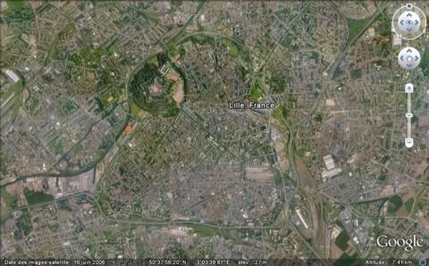
The citadel is completely preserved and still occupied by the army. Visits to the interior are possible when reserving via the tourist office. The outside area is a park of seventy hectares freely accessible, for which an upgrading project is currently being worked out. The urban wall was demolished after the First World War. All that remains are a few portions of walls, a medieval tower, two Spanish gates (Roubaix and Gand), and the porte de Paris. To document the urban wall and the modifications made by Vauban, we must turn to the relief map established in 1743, repaired in 1774, seized by the Prussians in 1815, having its country tables removed in 1903, bombarded in Berlin in 1945 and restored in 1948.
Lille
Lille
50° 38' 29.153" N, 3° 2' 37.1379" E
Type
citadel, urban wall and town planning
Engineers
Pierre Camp, Sébastien le Prestre de Vauban, Simon Vollant
Department
Nord
Region
Hauts-de-France
Bibliography
- BRAGARD (P.), CHEUVA (P.), COMBEAU (Y.), et al…, Etoiles de pierre. Voyage en Nord Pas-de-Calais, Villeneuve d’Ascq, 2003.
- HENRY (P.), La reine des citadelles, Lille, 2000, éd. La Voix du Nord.
- MILOT (J.), La citadelle de Lille, « Reine des citadelles », Lille, 1967.
- Ouvrage Collectif, Septentrion, le guide : entre Mer du Nord et Meuse, 19 villes fortes s’unissent pour inventer un idéal urbain, s. l., 2008, p. 44-45.
- SALAMAGNE (A.), Vauban en Flandre et Artois, les places de l’intérieur, Saint-Léger-Vauban, 1995.
- WARMOES (I.), Les plans en relief des places fortes du Nord dans les collections du Palais des Beaux-Arts de Lille, Lille-Paris, 2006.

