Gravelines
Historique et description
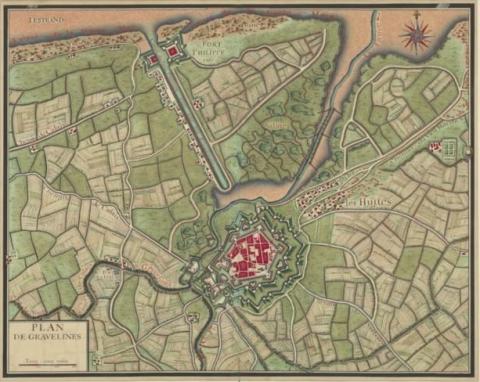
A site occupied by fishermen since the 7th century, Gravelines is a new town founded by the Count of Flanders, which serves as the outer harbour in Saint-Omer and which was surrounded by a first defensive wall in the form of an earth wall. After a siege by the English in 1383, the urban wall was replaced by grassed ramparts and brick walls. It was also endowed with a castle intended to oversee the locks of the river Aa and its first line of hydraulic defences. Between 1528 and 1535, Charles Quint had the castle reconstructed and modernised it with the addition of artillery installations and a bastion. The lock of the Bourbourg canal was reconstructed at the same time and transformed into a flushing lock, capable of emptying away the estuary sludge during the marsh at each equinox. His son, Philippe II of Spain, transformed the urban wall from 1558: a modern rampart with six great bastions and a glacis covering the medieval walls. The bastion of the castle was transformed and included in the hexagonal urban wall. The Italian engineers Ogiati, Thebaldi and Saluberto supervised all the construction carried out during the reign of Philippe II. His successors expanded the moats, added a covered way and a second exterior moat in 1637. They also had the fort Saint-Philippe constructed at the mouth of the Aa, channelled to protect the mooring facility from 1640, whereupon a second fort rapidly followed the first. The canal of Aa, meanwhile, was excavated from 1639, but French attacks in 1644 and 1652 interrupted this construction, which had to be continued up until 1658.Captured by the France in 1658, Gravelines was redesigned in the twenty-two years that followed. The intention was to transform it into a site included in the first line of defence. It was integrated into the Pré Carré in 1678. During this period, Spanish works were restored and further construction was undertaken. The ramparts were subject to significant renovation: the width of the protective wall was tripled with the construction of ravelins, counterscarps, projections and a covered way. Vauban stepped in for the first time in 1683 by reconstructing an artillery installation at the castle, which he turned into an arsenal. In 1699, he set out a significant flushing lock, which was installed on the Aa, and which allowed peripheral flood defences to be open or closed. This lock allowed the dredging of the channelled portion of the Aa and a corresponding increase in its flow. A vast hornwork protected this lock.
However, the scope of Gravelines would not extend beyond the second line of the Pré Carré. Accordingly, the construction program laid out by Vauban was only implemented progressively, based on the funding available. All this meant it was not until midway through the 18th century that they were completed with the deepening of the Aa channel in 1740. During this period, the former ravelins and counterguards were transformed and new ones were also added. The 19th century saw work proceed on an overall upgrade, but one which left the plan of the ramparts and flood defences in place. This upgrade involved reshaping the parapets, transforming the vaults of the bastion flanks, revegetating exterior works and restoring the hydraulic system. All the machines were replaced and the flushing lock of Vauban was entirely reconstructed.
Current state
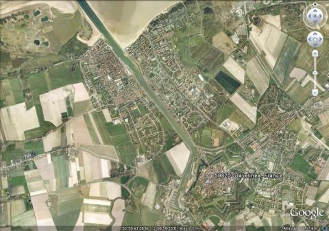
The set of fortifications of Gravelines and the moats survived and are now open to visitors. The ramparts have been restored and the green areas are also regularly maintained. The former protected walkway was secured as an area in which to stroll, offering urban and interior views. The garden established on the site of the former powder keg was reconceptualised; evoking the spirit of gardens of the past. The arsenal of the castle, still standing, is now used as an exhibition room and cultural centre, following a series of transformations made during the period 1970-1980. The powder keg functions as a museum and the barracks were reconverted into social quarters. Nothing further remains of the two Saint-Philippe forts. Only a mooring point at the mouth of the Aa canal, named Saint-Philippe fort, marks the spot where they once stood. The relief map of 1756 at a scale of 1/600, repaired in 1771 and 1819 and restored in 1986, is preserved at the Fine Arts museum of Lille. A copy was also presented to the museum of Gravelines.
Gravelines
Gravelines
50° 59' 9" N, 2° 7' 42" E
Type
urban wall, hydraulic defence
Engineers
Giovanni Maria Olgiati, Francesco Thebaldi, Adriano Saluberto, Sébastien le Prestre de Vauban
Department
Nord
Region
Hauts-de-France
Bibliography
- BRAGARD (P.), CHEUVA (P.), COMBEAU (Y.), (et alii), Etoiles de pierre. Voyage en Nord Pas-de-Calais, Villeneuve d’Ascq, 2003.
- FAUCHERRE (N.), Places fortes, bastions du pouvoir, Paris, 2000, p. 95-97.
- Ouvrage collectif, Septentrion, le guide : entre Mer du Nord et Meuse, 19 villes fortes s’unissent pour inventer un idéal urbain, s. l., 2008, p. 34-35.
- Ouvrage collectif, Vauban, sa vie, son œuvre, Paris, 1998, p. 49-50.
- TONNEAU (D), Gravelines de la place-forte à la ville contemporaine. Histoire et patrimoine, Gravelines, 2007.
- WARMOES (I.), Le Musée des Plans-Reliefs, Paris, 1997, p.30.

