Mont-Louis
History and description
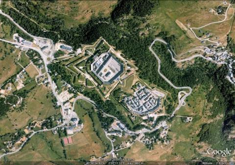
Mont-Louis is one of the new towns, completely created by Vauban. Its creation dates from spring 1679. The catalyst for its formation was the need to defend the French portion of the Region of Cerdagne, which had not been done since the treaty of the Pyrenees of 1659, twenty years earlier. It also reflected the need to respond to the presence of the Spanish fortress of Puigcerdà. The war of Holland proved the need to ensure a defence of this sector. Vauban designed a town with bastioned ramparts in a trapezoidal shape with three bastions and two ravelins. This town was dominated by a square citadel with four angled orillon bastions, the ramparts of which were preceded by dry moats, three ravelins (one of which on the front turned towards the town), a counterguard and a covered way. The citadel included barracks along the entire length of its curtain walls, as well as a long wall, which bisected the internal area of the citadel. It included a well twenty-eight metres deep, including a squirrel cage wheel. Another well supplied the town. The ramparts of the citadel and the town were flanked with echauguettes. The gate of the town and the two gates of the citadel were equipped with vaulted corridors, portcullis and drawbridges. The construction of the citadel and the ramparts lasted from 1679 to 1681. The town-planning was only completed from 1720. Joblot, the engineer tasked with this project, largely emulated the projects of Vauban. However, only the citadel and Ville Haute (upper town) were constructed, and not the Ville Basse (lower town) or the exterior redoubt.From 1887, fortified constructions were built on surrounding high locations to complete and modernise the defensive array.
Current state
The town and citadel are entirely preserved, likewise all their equipment (echauguettes, drawbridges, etc.). The citadel is used by the Centre National d’Entraînement Commando (National Commando Training Centre). Visits to the interior are allowed every day via the tourist office. This is a resource shared between the municipality and the defence, similarly with the solar furnace and the Natural Regional Park of the Catalonian Pyrenees exists for optimal networking of natural and cultural heritage. The whole set of works has been included on the World Heritage List as part of the fortifications of Vauban.
Mont-Louis
Mont-Louis
42° 30' 34" N, 2° 7' 13" E
Type
citadel, urban wall, town planning
Engineers
Sébastien Le Prestre de Vauban, Baptiste Joblot
Department
Pyrénées-Orientales
Region
Occitanie
Bibliography
- AYATS (A), Louis XIV et les Pyrénées catalanes de 1659 à 1681 : frontière politiques et frontières militaires, Perpignan, 2002.
- CANDAU (S.), FAUCHERRE (N.), Mont-Louis « la Militaire », Woippy, 2013.
- FAUCHERRE (N.), La route des fortifications en Méditerranée, Paris, 2007.
- FAUCHERRE (N.), BODIN (B.), Vauban, les sites majeurs, Grenoble, 2007, p.64-69.
- LENOBLE (J.-L.), Présentation du contexte et des terrains géologiques de Mont-Louis pour le dossier de classement à l’Unesco, s. l., 2006.
- MARCET (I.), JUNCOSA (A.), Abrégé d’histoire des terres catalanes du nord, Perpignan, 2001.
- PAILLISSE (M.-A.), Mont-Louis place forte et nouvelle (1679-1740), Montpellier, Université P. Valéry-Montpellier, 1982, (Mémoire de Maîtrise en Histoire III).
- SAHLINS (P.), Frontières et identités nationales : la France et l’Espagne dans les Pyrénées depuis le XVIIe siècle, s. l., 1986.
![Mont-Louis, plan de 1693, dans Recueil des plans des environs de plusieurs places du Royaume faits en l’an 1693, [Paris], pl. 43, gallica.bnf.fr / Bibliothèque nationale de France. Mont-Louis, plan de 1693, dans Recueil des plans des environs de plusieurs places du Royaume faits en l’an 1693, [Paris], pl. 43, gallica.bnf.fr / Bibliothèque nationale de France.](/sites/default/files/styles/paragraphe_libre/public/images/plan_ancien-89.jpg?itok=cWc7ebBr)
