Le Quesnoy
History and description
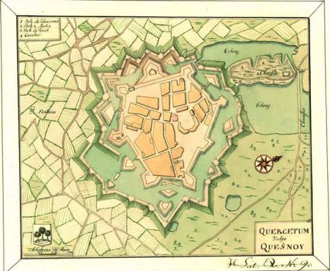
A town founded around 1150, on a crest for sharing of waters between two tributaries of the Escaut, by the Count of Hainaut, Beauduin IV. Le Quesnoy has had a castle and ramparts ever since it first came into being. The first urban wall comprised crenelated walls with a protected walkway and punctuated with circular towers. It was preceded by a ditch and flood defences in certain areas. The castle was square-shaped, with four angled towers and a central keep. In 1314, the Count of Hainaut Guillaume I reinforced these medieval fortifications. In particular, this involved partially replacing the protective medieval wall with a modern urban wall under the Spanish occupation from 1527. Five arrow headed bastions were placed in front of the ramparts and led to the disappearance of the majority of Middle Age towers. The route of the defensive walls was subject to partial rectifications, earth was placed behind the walls, the flood defence system was improved and divided into three main pools. The four medieval gates were preserved in an initial period, until Charles Quint had the Porte de Flamengrie walled in 1543 to improve the water defence. Under his orders, the area surrounding the stronghold was cleared and earth ravelins were constructed around the moats. Philippe IV of Spain ordered repairs between 1639 and 1642. The ramparts were restored and palisades were fitted. Guardrooms and detached works were built within and in front of the gates, whether preserved or not. An earth ravelin was added. All the ravelins were equipped with fraises, false ramparts and covered walkways with palisades. The third gate of the urban wall, the porte Saint-Martin, included two successive ravelins to flank it. The fourth gate, the porte de Fauxroeulx, redesigned and reconstructed identically with two towers received the final ravelin constructed during this period. Besieged multiple times by France and the Netherlands from the reigns of Louis XI of France and Charles the Bold of Burgundy, the town was taken under Louis XIV in 1654 and returned permanently to France by the treaty of the Pyrenees in 1659.Following the cession of the town, the initial French construction consisted of a restoration of the stronghold, which had been pillaged by the Spanish before their defeat in 1654. On this occasion, the Saint-Martin gate was walled, which left only the porte de Valenciennes and porte de Fauxroeulx to be enter.
From 1654 to 1657, the Talon brothers, intendants of the region, had the damage caused by the siege of 1654 repaired. In 1659, the engineer La Touche proposed a vast map of modernisation: which would involve the five bastions being separated from the main enceinte, the ravelin of the porte Forest having to be expanded and refurbished and the eastern part of the urban wall, still medieval, would have to be defended by a sort of hexagonal citadel lacking an outpost against the town. This project did not come to fruition, however, except for a counterguard in front of the bastion Vert and the addition of the bastion Royal, formed identically to the Spanish bastions of Charles Quint. Vauban intervened from 1668. He reconstructed the two fronts of the bastion Royal with obtuse flanking and restructured all the existing bastions into curved arrow headed bastions. The demi-bastion of the castle was added, the ravelins were rectified, the salient point of the south-west part of the urban wall was separated by the addition of two other bastions (bastion du Saint-Martin and bastion du Gard) and a tenaille, while a Spanish bastion was redesigned as a ravelin. The facings and moats were completely replaced and the parapets were elevated. The cofferdams and the dike of the étang d’Aulnoye pond were constructed in 1672. The étang du Fer à Cheval (the Horse Shoe Pond) and the redoubts completed the set of defences. The repairing was suspended in 1673 by the War of Holland but continued again two years later with the creation of the étang du Pont Rouge (Red Bridge Pond) and an unfinished project involving the construction of a hornwork to replace the demi-lune Fauxroeulx (Fauxroeulx ravelin). Two additional counterguards were constructed in front of the bastion Soyez and the bastion César between 1680 and 1686. Following this construction, Le Quesnoy was integrated into the first line of the Pré Carré. In 1698, after the war of the League of Augsbourg, Vauban drew up a final modernisation project: the earth ravelins from fronts 6 to 8 would have to be reworked in stone, expanded and given tenailles, the counterguard of the bastion Soyez would have to be completed and another one added to the bastion Impérial. The defence for the porte de Fauxroeulx had to be improved by an entrenchment between the two defensive ponds. The engineer Génédot, commissioned to come on-site, criticised it but did not offer any alternative suggestions. The works specified by Vauban were not carried out.
In 1710, two lunettes were constructed at the site of the unfinished hornwork at the Porte Saint-Martin. The Dutch, who had occupied the town since 1712, completed the Vauban project of a hornwork at the Porte de Fauxroeulx and constructed a counterguard at the Bastion Saint-Martin, as well as three ravelins near the castle in 1713. The 1720s saw further improvements made along the lines of the projects of Vauban of 1700 : construction of external redoubts and replacement of the Ouvrage à corne Fauxroeulx (Fauxroeulx hornwork) by one smaller one. In the 19th century, the castle barracks were reconstructed and stone-built or terraced casemates were included in the different works. Séré de Rivière constructed casemated shelters in 1878, following the reclassification of Quesnoy as a stop fort.
Current state
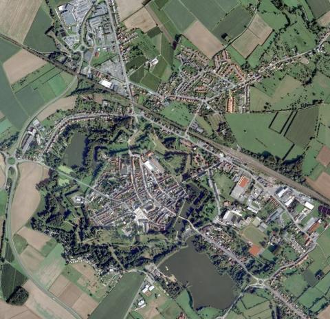
The set of ramparts present at Le Quesnoy endure. Definitively downgraded in 1901, they have been restored by the town since 1980 and are regularly maintained. A voluntary policy has encouraged the reclaiming and use of these spaces (family gardens, walking areas, lagoons...). As regards to hydraulic defences, two of the three pools still remain and are subject to minimal maintenance following periodic assessment. That in the east disappeared, to be replaced by a lawn.
Le Quesnoy
Le Quesnoy
50° 14' 59" N, 3° 38' 18" E
Type
urban wall
Engineers
La Touche, Sébastien le Prestre de Vauban, Raymond-Adolphe Séré de Rivières
Department
Nord
Region
Hauts-de-France
Bibliography
- DEBRABANT (B.), La fortification du Quesnoy au dix-huitième siècle, Le Quesnoy, 1981.
- DEBRABANT (B.), La fortification du Quesnoy au dix-septième siècle, Le Quesnoy, 1983.
- DEBRABANT (B.), Vauban et la fortification du Quesnoy au XVIIe siècle, Le Quesnoy, 2007.
- DUVIVIER (J.), Le Quesnoy, ses annales, ses sièges, ses fortifications, Lille, 1934.
- FAUCHERRE (N.), HANSCOTTE (F.), La route des villes fortes en Nord, Paris, 2003.
- Ouvrage collectif, Septentrion, le guide : entre Mer du Nord et Meuse, 19 villes fortes s’unissent pour inventer un idéal urbain, s. l., 2008, p. 42-43.
- Ouvrage collectif, Vauban, sa vie, son œuvre, Paris, 1998, éd. Les Amis de la Maison Vauban, p. 51-53.

