Antibes
History and description
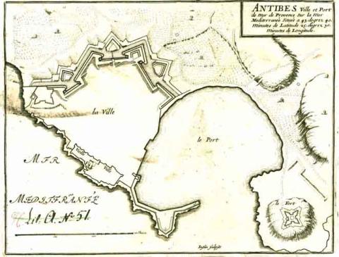
A town of Greek origin, founded by the Phoeceans around 430 BC, the first urban wall in Antibes was built in Late Antiquity. In medieval times, a further urban wall including multiple round towers, which was repaired around the 14th century, surrounded it but this was, however, crowded out by new constructions which filled entire districts. The Hispano-Savoy invasions in 1524 and 1536, ordered by Charles Quint, showed the dangers of these urban excesses. On each occasion, the town was conquered and completely devastated. To guard against any repeat, Francis I ordered the construction of a new urban wall surrounding the former outer suburbs. The medieval urban wall was removed. New fortification was constructed under the reigns of Henri II and III. This fortification was a modern urban wall, which included bastions and projections. In 1554, the engineer Henri de Mondons walled off the market town situated to the north of the city, by expanding the urban wall, which Henri IV proceeded to modernise. Raymond De Bonnefons, engineer in charge of Bresse, Dauphiné and Provence, designed a new line of walls with four bastions, which further expanded the perimeter of the urban wall. In 1640, Pierre de Bonnefons, the stepson of Raymond, worked on a new project to improve the city defences. This project consisted of adding three ravelins and a flat bastion onto the sea wall but the construction work was interrupted. The fort Carré was built on the orders of King Henri III of France in 1585. It featured a fortified square with four bastions, including a tower with barracks. In 1552, the engineer Henri de Mandon, Lord of Saint-Remy, constructed the tour de Saint-Jacques on the island of the same name, in order to protect the mooring.Vauban visited Antibes in 1679 and 1682. He had completed an elaborate project some years earlier. This involved reinforcing the fort Carré, expanding the town to the east and deepening the port. He also moved to pull down the tour de Saint-Jacques, lower the walls, deepen the moats and construct cavaliers on the bastions. Although engineer Niquet complied, the work to expand the town towards the fort Carré, a project reaffirmed by Vauban in 1704, did not come to pass.
Between 1767 and 1769, the route of the glacis was subject to modifications, which were later, however, criticised by the Marquis of Paulmy, the War Minister of Louis XV, who was of the opinion that the engineer had not correctly followed the plans of Vauban.
Current state
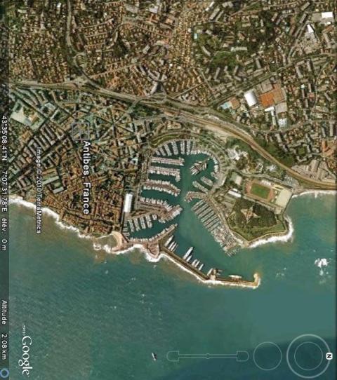
The stronghold was downgraded in 1889 and the walls demolished after 1895. Today, one bastion is all that remains near the jetty of the port. To document them, a look at the relief map of 1747 suffices, preserved at the musée des Invalides in Paris. The fort Carré remains well preserved. No longer used for military purposes in 1860, it became barracks up until 1967, the year the town fell. Restored from 1979 to 1985, it has been open to the public since 1998 and can be visited if contacting the local tourist office.
Antibes
Antibes
43° 34' 51" N, 7° 7' 26" E
Type
fort and urban wall
Engineers
Henri de Mandons, Raymond de Bonnefons, Pierre de Bonnefons, Sébastien le Prestre de Vauban, Antoine Niquet, Pierre-Jean de Caux de Blaquetot
Department
Alpes Maritimes
Region
Provence-Alpes-Côte d'Azur
Bibliography
- ADGE (M.), CATARINA (D.), et alii, La route des fortifications en Méditerranée, Paris, 2007.
- CALVAYRAC –REYNE (C.), RIBIERE (H.), “Le fort Carré d’Antibes ou fort Championnet” in Vauban et ses successeurs dans les Alpes maritimes, Paris, 2004, p.131-141.
- D’AUNAY (A.), Vauban, génie maritime, Paris, 2007.
- FROISSARD (M.), « Les fortifications d’Antibes » in Vauban et ses successeurs dans les Alpes maritimes, Paris, 2004, p.121-129.
- PLANET (E.), Fort Carré, Antibes, 2008, Direction des Musées.

