Avesnes-sur-Helpe
History and description
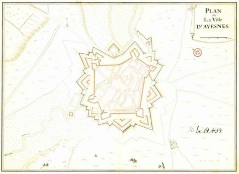
A town of medieval origin, Avesnes-sur-Helpe is the product of two older urban centres coming together, which first emerged around the 10th century and merged to form a single fortified agglomeration from the 12th century. The first urban wall was replaced in the following century. Meanwhile, the first artillery installations were set up on this urban wall during the 15th century, by the carving out of cannon embrasures in the towers of the porte Cambrésienne. From 1502 onwards, the town became a lordship of the Dukes of Croy, who were responsible for managing the fortifications, working alongside the central government of the Netherlands. Subsequently, at the initiative of Duke Philippe II of Croy, the first bastioned fortifications were constructed between 1534 and 1538. These were designed by the Italian engineer Jacopo Seghezzi and were the oldest fortifications of their kind in the Netherlands. During 1540 and 1550, the defensive installation was reinforced with cavaliers on bastions and curtain walls. In 1556, Philippe II of Spain regained seigniorial rights and Avesne became falls in the hands of the Spanish crown. From 1556 to 1659, engineers from Madrid and Brussels adjusted the routes of the fortifications, and constructed ravelins and redoubts to protect the gates. A further redoubt was added at the spot known as pont Rouge.Finally conquered once and for all by France in 1659 under the treaty of the Pyrenees, a new round of work aiming to modernise the urban wall was ordered in 1661. Vauban’s involvement began from 1673 when he designed the Pré Carré projects. The bastion de la Reine was slightly expanded and the external town defences (two redoubts, five ravelins and a flood barrier) were remodelled. This construction work prompted a boom in efforts to replace the former Italian fortifications with newer equivalents. The lock of the pont des Dames was installed and allowed for flood protection before the north front. In 1678, Avesnes-sur-Helpe was integrated into the first line of defence of the Pré Carré. The bridge-lock of the Dames was completed at the end of the 17th century and sealed with a cover in 1721. This lock allowed a vast body of water from the Helpe to be controlled.
In 1795, during the wars of the Revolution, two spires were constructed along the Vervins road. Partially destroyed during a siege in 1815, the town was reconstructed as part of the Restoration and had its fortifications modernised from 1821, following the losses of Philippeville and Mariembourg ceded to the Kingdom of the Netherlands. A vaulted demi-bastion on two levels was established near the porte de France, which was restored. The bastion de Saint-Jean was refurbished, its former casemates were blocked off and the powder kegs and stock houses were reconstructed. To document this modernisation, a new relief map was put together in 1826, replacing that of 1725, which had been seized by the Prussians in 1815. It takes account of the extension of the ramparts after this construction work.
Current state
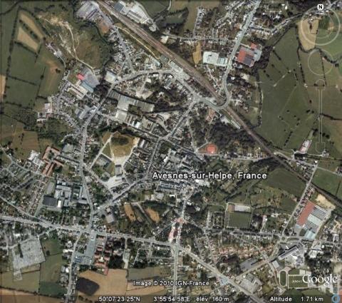
The decision was taken to demolish the walls in 1867. In place, lie avenues and a train station. Two parts, however, remain in place today: the bastion de la Reine (situated in the north-west, recently excavated by archaeologists and the development of which is currently being considered), the bastion Saint-Jean (recently cleared and restored), the bastion de France (occupied by the
Avesnes-sur-Helpe
Avesnes-sur-Helpe
50° 7' 19" N, 3° 55' 53" E
Type
urban wall and hydraulic defence
Engineers
Jacopo da Modena, Louis-Nicolas de Clerville, Sébastien le Prestre de Vauban
Department
Nord
Region
Hauts-de-France
Bibliography
- BRAGARD (P.), A la découverte des villes fortifiées du Hainaut. Avesnes-sur-Helpe, Bitche, Le Quesnoy, Maubeuge, s. l., 2001, p. 24-35.
- BRAGARD (P.), CHEUVA (P.), COMBEAU (Y.), et al…, Etoiles de pierre. Voyage en Nord Pas-de-Calais, Villeneuve d’Ascq, 2003.
- CROIX (C.), Les anciennes fortifications d’Avesnes, s. l., 1957.
- HANSCOTTE (F.), FAUCHERRE (N.), La route des villes fortes en Nord, Paris, 2005.
- SALAMAGNE (A.), Vauban en Flandre et en Artois : les places de l’intérieur, Saint-Léger-Vauban, 1995.
- WARMOES (I.), Les plans en relief des places fortes du Nord dans les collections du Palais des Beaux-Arts de Lille, Lille-Paris, 2006.
- WARMOES (I.), Le Musée des Plans-Reliefs, Paris, 1997, p.37-38.

