Bergues
History and description
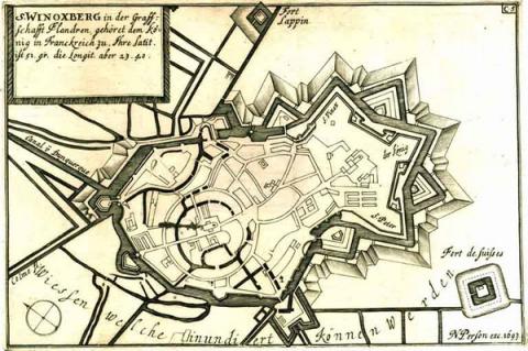
Medieval town, comprising two initial urban centres (the Saint-Winocq abbey and the new town of the count of Flanders Baudouin IV on the hill of Groenberg), Bergues expanded, thanks to its importance as a port, from the 9th century and gained its firsts fortifications, in the form of a urban wall and a castle (of the motte-and-bailey type). These walls would be modified and expanded multiple times, particularly in 1383, a year which finally saw the two urban centres merge to form a single whole. This rearrangement followed the siege of 1382 by the King of France Charles VI. The 15th century saw this urban wall reconstructed and adapted to house artillery with the addition of boulevards and couleuvrines. In the 16th century, the Spanish constructed bastions and two ravelins before the front west gates, from 1558 under the reign of Philippe II of Spain. From this time, the forces based there have resided within the area of flood defences, fed by the canal of Bergues, originating from the sea, and la Colme, a fresh water river. The towers of Coulevriniers, Sept-baraques and Neckerstor controlled this hydraulic installation. From 1635, work began on other constructed installations designed to reinforce these defences. Two square forts, the fort Lapin to the north and the fort Suisse to the south, were constructed shortly after this date. Detached fortifications were also constructed in front of the oriental fronts of the town, weak point of the defence, since it lacked water-based protection.First conquered in 1646, the town would not fall conclusively into French hands until 1668, with the treaty of Aix-la-Chapelle. The same year, Vauban was commissioned to modernise the defences. His first project, applied from 1670, consisted in reinforcing the oriental front of the town, the only area lacking the water defences. Here, he constructed a crown head (a variation of the coronation work) including a bastion and two semi-bastion, thus creating two fronts, each of which preceded by a tenaille and a ravelin. This set was known as couronne Saint-Winocq, given the fact it was in the vicinity of the abbey of the same name. These initial constructions came into existence in 1677, the year it was integrated into the second line of the Pré Carré. After this date, work commenced on inner fortified structures, ravelins and lunettes of the crown. In fact, Vauban added a redoubt and modernised the existing redoubt (redoute des Dunes), thus carrying out the work in question in reverse. In 1699, he completed a third round of work on this part of the ramparts: communication and fighting tunnels were added, as well as integrating ravelins and moats. The hydraulic defences saw their locks upgraded for greater efficiency. A similar successful work project to protect the porte de Dunkerque, to the north of the stronghold, would not be realised until 1744. Elsewhere, Vauban’s intervention was limited to improving the layout of the works and replacing the porte de Cassel and porte de Hondscoote. In the town, he constructed barracks and powder kegs.
The 18th century passed with the appearance of the location only little changed: an elevated cistern was added in 1724. In the 19th century, multiple construction projects got underway, however. The first of these was launched under the July Monarchy: involving the hornwork of the south gate being replaced by a suburb said to be from Biesme, surrounding the station and the new canal. This construction work ran from 1840 to 1850. The suburb of Saint-Winocq was modernised after 1870 to be adapted to rifled artillery. During the occupation of 1940-44, the ramparts were used by the Germans for shooting training.
Current state
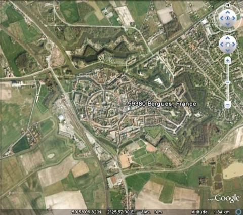
The town has preserved almost all of its ramparts. The hornwork protecting the southern gate, the two bastions entrenched from the west and the redoubt fort François, situated along the north-west canal were demolished. The moats were also excavated in this area. The other drains and ramparts are preserved but covered in undergrowth. Visiting is possible, either with or without a guide. The relief map of the town, constructed in 1699 at a 1/600 scale, repaired in 1771, still exists and is preserved at the musée des Beaux Arts (museum des Fine Arts) in Lille.
Bergues
Bergues
50° 58' 8.558" N, 2° 25' 47.3556" E
Type
urban wall
Department
Nord
Region
Hauts-de-France
Bibliography
- BRAGARD (P.), CHEUVA (P.), COMBEAU (Y.), et al…, Etoiles de pierre. Voyage en Nord Pas-de-Calais, Villeneuve d’Ascq, 2003.
- BRAGARD (P.), TERMOTE (J.) et WILLIAMS (J.), A la découverte des villes fortifiées : places fortes du Kent, de la Côte d’Opale et de la Flandre occidentale, Canterbury = Lille, 1999, éd. Réseau des villes fortifiées.
- FAUCHERRE (N.) et HANSCOTTE (F.), La route des villes fortes en Nord, Paris, 2003, éd. Le Huitième Jour, coll. Les étoiles de Vauban.
- SALAMAGNE (A.), Vauban en Flandre et en Artois : les places de l’intérieur, Saint-Léger-Vauban, 1995.
- WARMOES (I.), Les plans en relief des places fortes du Nord dans les collections du Palais des Beaux-Arts de Lille, Lille-Paris, 2006.

