Fort Pâté
History and description
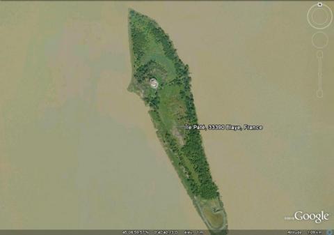
The fort Pâté is a compact tower with an artillery platform, an example of this genre, installed on an isle in the middle of the Gironde estuary. With the citadel of Blaye and the fort Médoc, the fort Pâté allows passage on the water to be cut off via crossfire. It was constructed between 1689 and 1693.Designed for twenty men, the building is a ring-shaped casemate, equipped with a freshwater cistern, a chapel and a powder keg. It represents a real architectural feat, since the instability of the ground required the fort to be built atop a wooden sill.
Current state
The fort is private property and subject to minimal maintenance. The triptych on the estuary is included on the World Heritage List as part of the fortifications of Vauban. The relief map still exists and is on show at the musée des Invalides in Paris.
Fort Pâté
Fort Pâté
45° 7' 3.7578" N, -0° 40' 42.4153" E
Type
compact artillery tower
Engineers
Sébastien le Prestre de Vauban, François Ferry
Department
Gironde
Region
Nouvelle-Aquitaine
Bibliography
- COLAS (P.), Blaye, citadelle, boulevard du château, étude préalable, Bordeaux, 1991.
- COUTURA (J.), « Vauban à Blaye », in Les cahiers du Vitrezais, Paris, 1983, n°43.
- COUTURA (J.), « Quelques notes pour servir à l’histoire de la citadelle de Blaye, de Fort Pâté et Fort Médoc » in Les cahiers du Vitrezais, Paris, 1983, n°46.
- COUTURA (J.), « La construction du fort Pâté au milieu de la Gironde (1689-1693) » in Revue archéologique de Bordeaux, Bordeaux, 1991, t. LXXXII.
- Dossier de presse, candidature au patrimoine mondial de l’humanité, Cussac-Fort-Médoc, 2005.
- FAUCHERRE (N.), « La citadelle de Blaye », in Congrès archéologique de France, Paris, 1990, 145e session.
- WARMOES (I.), Le musée des plans-reliefs, Paris, 1997, p.58.

