Valenciennes
History and description
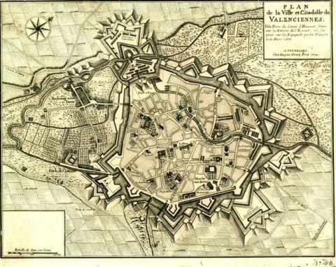
Situated on the confluent between the Escaut and the stream of the Rhônelle, the first agglomeration of Valenciennes appeared during the Roman period, on a site previously occupied by the Gauls. The first fortifications dated back to the 10th century. Small forts were built on either side of the confluent towards 250. A century later, emperor Valentinien had the first urban enclosure built and elevated it to the rank of a town (in around 364-367). This was not enough to prevent it being pillaged by the Huns, and later the Vandales in around 406 AD. Under the Merovingians and the Carolingians, Valenciennes gained in importance and developed further. The Roman fortifications seem to have been well preserved and surrounded the original nucleus comprising the eglise Notre-Dame-du-Saint-Cordon, the eglise Saint-Vaast and the Merovingian abbaye de Saint-Jean. The counts of Valenciennes constructed a castle at the start of the 9th century, on the site of the future fortress of the Modern Era. In the 12th century, the count Beauduin l’édificateur (Beauduin the constructor) expanded the urban wall and the town in order to reconstruct a new palace and include nearby hamlets. This new urban wall was constructed to include battlements, machicolation and wooden hoardings. A ditch preceded the ramparts. They were equipped with towers on two levels possessing the same equipment as the walls. Several gates were included in the ramparts. The route of this urban wall has been mostly preserved up to the 19th century. The castle was modified at the end of the 13th century and its area was increased, likewise its defences. From 1345 to 1380, the ramparts and the castle accommodated new defensive constructions for the purpose of modernisation, during the Hundred Years war.Around 1477, the town constructed an artillery rampart to protect its gates. The first modern work was constructed in 1525, which was the bastion Cardon (Cardon bastion), near the gate of the same name. From 1529, the entire south-west flank of the urban wall was modernised as directed by the engineer de Charles Quint, D’Aerschot and his workers. In 1540, Charles Quint ordered a general recasting of fortifications which got underway in 1542. The first hydraulic defences were installed two years later. These included, among others, the écluse de la Bretêche and the écluse des Repenties (two locks). Their installation was also intended to regularise the flow of the Rhônelle. From 1546, the ramparts of the east were reconstructed. This construction was finally completed, it seems, around 1551. Urgent work got underway in 1566-1567 during the Religious wars, but the south-west and west flanks had not yet been modernised by that time. The first citadel was constructed in 1570-1573 by the duke of Alba. It consisted of a redoubt which then disappeared in 1577. From 1578 until the reign of Archidukes Albert and Isabelle, governors of Spanish Netherlands, the last medieval sections of the ramparts were replaced with modern ramparts. The portions concerned were the north, west and south parts of the urban wall. Initially in the form of palisaded earth, the escarpments of works were progressively made of stone from 1600 to 1654 and certain moats were deepened. From 1656 to 1677, six ravelins were constructed. A hornwork was added in front of the porte de Cambrai and a crownwork was constructed on the hill of Anzin. The hydraulic works were also improved.
Taken by the French in March 1677, a siege in which Vauban participated, Valenciennes was integrated from the following year into the first line of the Pré Carré. From 1677, Vauban constructed a citadel there, which survived two centuries. This citadel had an irregular shape. A front with small-scale bastions faced the town. Two other fronts were faced towards the countryside and protected by floods and a crownwork equipped with two fronts. The counterscarps of the urban wall were coated and extra bastions were added to the fronts constructed under Charles Quint in order to in improve the flanking. Several fronts were rectified and improved. The front de Famars and the front de Mons were completely reworked. The two locks of Charles Quint were renovated and others, such as the écluse de Notre-Dame and the écluse des Repenties were constructed, as well as dikes to bolster and reinforce defensive ponds. The covered ways were equipped with hook-like traverses, according to the relief map from 1694. Barracks were also constructed in both the town and the citadel.
The starting point of the 18th century saw further improvements made to the defences of the stronghold: several lunettes and advanced works were constructed during the Spanish War of Succession in order to reinforce the protection of the western side of the ramparts of the town and the citadel. There is also evidence of improvement works on the construction during the War of Succession of Austria. Some advanced works and a counterguard were constructed during this period. The scope of the majority of the construction was limited to simply finishing off the original work of Vauban. The engineer Filley implemented these modifications and improved the projection of the works, the purpose of some of which was also changed. From military installations, some became simple depots. During the Austrian siege of 1792, three lunettes were added. The Austrians did little to upgrade these defences up until 1794. Downgraded until 1815, Valenciennes was partially reconstructed under the French Restoration, and this work was continued under the July Monarchy. This completed the modifications which had been started by the Austrians and resulted in the construction of the first detached forts worthy of the name. The lunette Dampierre was inaugurated by the French Second Republic in 1850, with this objective in mind. The French Second Empire went ahead with the modifications while preserving Valenciennes and equipping it with sheltered traverses. Under the Third republic, meanwhile, a peripheral fort of the Séré de Rivières style was constructed in 1881: the fort de Curgies. The invention of the melinite, a new explosive far more powerful than normal gunpowder, prompted the final downgrading of Valenciennes in 1889.
Current state
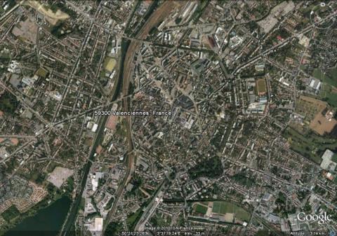
The stronghold of Valenciennes was taken apart between 1889 and 1893. Avenues and middle-class districts replaced the ramparts and the citadel. Only a medieval tower, the tour de Dodenne and a flushing lock along the canal de l’Escaut still remain.
Valenciennes
Valenciennes
50° 21' 11.803" N, 3° 29' 13.839" E
Type
citadel, urban wall and hydraulic defences
Department
Nord
Region
Hauts-de-France
Bibliography
- BRAGARD (P.), CHEUVA (P.), COMBEAU (Y.), et al…, Etoiles de pierre. Voyage en Nord Pas-de-Calais, Villeneuve d’Ascq, 2003.
- MARIAGE (E.), sous la dir. de, Les fortifications de Valenciennes, Valenciennes, 1895, éd. Société d’Agriculture, Sciences et Arts de Valenciennes.
- SALAMAGNE (A.), Les fortifications de Valenciennes du 12e au début du 16e siècle. Leur place dans l’architecture militaire, dans La Revue du Nord, t. LXVI, 1984.
- SALAMAGNE (A.), A la découverte des anciennes fortifications de Valenciennes, Cambrai, 1999, éd. Nord Patrimoine.
- SALAMAGNE (A.), Vauban en Flandre et Artois, les places de l’intérieur, Saint-Léger-Vauban, 1995, éd. Les Amis de la Maison Vauban.

