Mézières
History and description
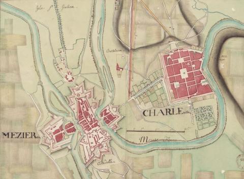
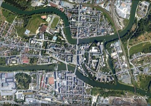
Situated in a bend between two arms of the Haute Meuse, Mézières gets its name from the first castle established under Charlemagne in 812 (Macerianae). This first castle was made of wood and raised earthworks. Destroyed by fire in 897, it was immediately reconstructed in stone. Its location is on a spur dominating the two arms of the river. It was oblong in shape and dominated by a motte with a wooden keep, later reconstructed in stone. The main gate is likely to have been situated where the rue du Château currently lies. It also included a castel chapel, constructed in the collegial around 1200, entirely reconstructed in the Gothic style and including a cloister from the same period. The town developed progressively from the base of the castle. Hughes III, Count of Rethel and Overlord of Mézières, ordered the construction of the first urban wall around this town in 1233. This urban wall formed an irregular quadrilateral, bathed to the north and south by the Meuse, surrounded by a dozen round towers and a crenelated walkway, which was subsequently covered by a candle snuffer roof. A gate was found at each cardinal point. Two fortified bridges were built across the river. This urban wall was repaired multiple times but the formation of four suburbs, Saint Julien to the west, Arches to the north, Pont-de-Pierre to the south and Bertancourt to the east, led to the replacement of the urban wall in the 13th century by a new one which enclosed them. This urban wall was completed in around the 16th century. The 1500s years thus saw the medieval keep transformed into a cavalier. The ramparts were thickened and artillery installations were added.The first modern urban walls were constructed in front of the Western gate: including an orillon bastion and a ravelin (the As de Pique). The whole set was constructed in around 1594-1597 by Louis de Gonzague, governor of the town. The citadel was created in 1589 by the Count of Saint-Paul, Lieutenant General of Champagne, who found himself rebelling within the Catholic League against Henri III then Henri IV. The oriental town disappeared on this occasion, razed in order to construct the citadel. An initial bastioned front of stone was constructed from 1590 to 1593 against the local town and Duke’s palace. The Spanish supported its construction, and one of their engineers is even presumed to have been involved. This front included three bastions, one in the centre and two on the flanks. However, all this was not enough to prevent the citadel being captured by the armies of Henri IV in 1593. Subsequently, what had become a royal citadel was modified between 1600 and 1651 by the addition of further construction in the east: a front with three bastions was constructed there, preceded by an inner ravelin. A gate was also made there. A bastion was also built on the north front. The urban wall had bastioned constructions added in the 16th and 17th centuries, before Vauban. However, these were nothing more than constructions made of wood and earth.
Vauban intervened in Mézières from 1675, when he incorporated it into the second line of the Pré Carré. The urban wall was completely bastioned. The three surviving suburbs were surrounded by expansive hornworks. That on the west was flanked on its north and south sides by ravelins. It was cut in the centre of town by another hornwork equipped with a moat and flanked by two detached bastions. That of the south was separated from the centre by the Meuse and an inner fortified structure. It was also flanked by two detached bastions near to the river. The third, situated to the north, was the simplest, since it was only flanked by a single detached bastion. Two counterguards were also added to the south. All the moats were filled. The barracks of the fortress were constructed in 1687. In 1692, Vauban declared in a letter for Louis XIV that Mézières was operational. The construction led to a pulling back from the habitable area of the suburbs, which prompted displaced habitants to leave Mézières for Charleville, created by Charles de Gonzague as a new town one kilometre downstream in 1606.
The 18th century saw modification of the urban wall of Mézières with the construction of the crownwork of Champagne and extending the length of the fronts of the suburbs of Saint-Julien and Arche. The citadel was not involved. Following the bombardments and Prussian siege of 1870, the citadel and urban wall were downgraded, while a fort of the Séré de Rivières style and a battery were constructed on the site of Ayelles, some kilometres from the town, in 1877. This fort was a square design, equipped with everything required to be autonomous and two shelters constructed with the bartizans restored during the demolition of the ramparts and of the citadel, started in 1872.
Current state
The urban wall was largely demolished. The remains include a few medieval towers and a gate. Of the citadel, two bastions and the barracks still remain. This latter site was transformed into an administrative area. The whole facility can be visited. The Séré de Rivières battery was largely destroyed during the Second World War and the fort des Ayelles is not open to visitors.
Mézières
Mézières
49° 46' 19" N, 4° 42' 58" E
Type
citadel and urban wall
Engineers
Sébastien le Prestre de Vauban
Department
Ardennes
Region
Hauts-de-France
Bibliography
- MARTIN (P.), La route des fortifications dans l’Est, Paris, 2007.
- Ouvrage collectif, Les fortifications de Mézières, s. l. n. d.
- Ouvrage collectif, « L’histoire de la citadelle de Mézières » in Revue historique ardennaise, s. l. n. d.

