Bayonne
History and description
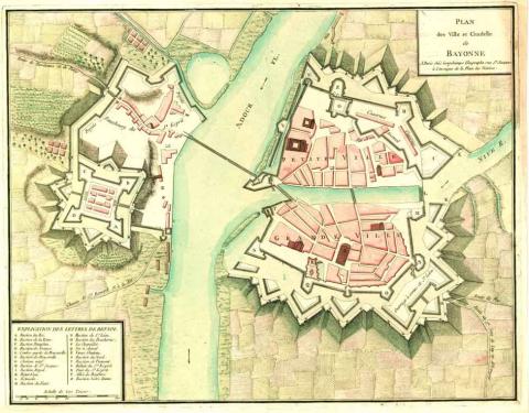
A town of Roman origin situated where the Adour and Nive rivers meet, six kilometres from the Atlantic Ocean, Bayonne had its own Roman castrum in the 4th and 5th centuries. Abandoned under the Merovingians, and with at least one urban wall since the 12th century, it was besieged by the Spanish on multiple occasions in the 15th-16th and 17th centuries. This prompted Louis XII and Francis I to build a new urban wall and the New castle.In 1681, Vauban remodelled this ancient site by improving the above installations and designed projects including the citadel and the entrenchment of Saint-Esprit. The works were conducted by the engineer Ferry and completed in 1685. During this construction work, the château Neuf (New castle) was completely renovated and equipped with all the elements required for a citadel worthy of the name: magazines, mills, wells, chapel, as well as a new gate. Twelve hundred soldiers would have been housed in its garrison. Other projects and modifications were proposed and implemented up until 1713, when the treaty of Utrecht saw Bayonne lose its strategic importance.
During the 18th century, the fortifications were subject to multiple construction phases, boosted by the port facilities and a concern over embellishment. The Restoration and the July Monarchy modified the fortifications to make them optimally effective for artillery manoeuvres, something which had been found sorely lacking during the allied siege of 1814.
Current state
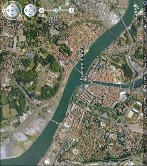
The citadel is completely preserved. It has been partially converted into a residential and commercial facility. The majority of the ramparts remains and has been changed into a city park. Some has been converted. The bastion Sainte-Claire, with the land it contained removed, currently houses a park and ride facility while the curtain wall of a front is occupied on its inner side by a university library, the Florence Delay library. The glacis of the tour du Sault is adjacent to an athletic stadium and a renovation project underway on the right bank of the Adour, along the citadel, is currently being studied and should be realised in 2015. The majority of the fortifications are classed as a historical monument. The ramparts can be visited either unaccompanied or with a guide if you contact the tourist office. The relief map of the stronghold, constructed in 1820, is preserved at the musée des Invalides in Paris.
Bayonne
Bayonne
43° 29' 37" N, -1° 28' 30" E
Type
citadel and urban wall
Engineers
Jean de Cologne, Galiot de Genouillac, Guyon le Roy, Louis de Foix, Jean Errard de Bar-le-Duc, Nicolas Desjardins, Dubois d’Avancour, Deshoulières, Sébastien le Prestre de Vauban, François Ferry
Department
Pyrénées-Atlantiques
Region
Nouvelle-Aquitaine
Bibliography
- Habiter les villes fortifiées, histoire, conservation, rénovation et défis urbains, Bayonne, 2010, (dossier de presse de l’exposition au musée basque, du 16 septembre 2010 au 16 janvier 2011), http://www.musee-basque.com/actu/villes-fortifiees_sept2010/dossier_presse.pdf, p. 12.
- DANGLES (P.), FAUCHERRE (N.), « Les fortifications du Bourgneuf à Bayonne, état de la question. Nouvelles hypothèses » in Revue d’histoire de Bayonne, du Pays basque et du Bas-Adour, Bayonne, n°146, 1990.
- DE PASCAU (M.), « El patrimonio fortificado de Bayona : Historia, conservacíon, reutilizacíon” in Ciudades amuralladas: lugares para vivir, visitar e innovar. Pampelune, 2013, p.140-149.
- LACROCQ (N.), Atlas des places fortes de France (1774-1788), Vincennes, 1981.
- LE BLANC (F Y), FAUCHERRE (N.), La route des fortifications en Atlantique, Paris, 2007.
- RIBETON (O.), « El patrimonio fortificado de Bayona » in Ciudades amuralladas: lugares para vivir, visitar e innovar. Pampelune, 2013, p.129-139.
- WARMOES (I.), Le Musée des Plans-Reliefs, Paris, 1997, p.56-57.

