Brest
History and description
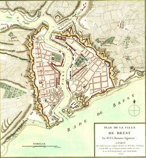
A town of Roman origin, Brest had the first fortification built in the 3rd century. At the time, this was a small fort with a coastal defence. This fort was replaced by a medieval castle from the 12th century. Up to the 16th century, the agglomeration was limited to the urban wall of the castle, given the difficulties of developing what was a steep site, situated in the estuary of the river Penfeld, in the absence of fertile land to the rear. In the 16th century, the start of urban development saw the emergence of two market towns: Brest on the left bank of the river, Recouvrance on the right. Around 1600, the two market towns having merged had a collective population of around one thousand five hundred people. The medieval castle was surrounded by bastions around 1530 and the first rope factory was constructed under Richelieu. An initial modern first urban wall was built by a certain Julien Ozanne in 1655, according to sources and documents.In 1661, the appointment of Colbert as Minister was the catalyst for the first significant investment made for the port of Brest. Twelve years later, the main arsenal of the French Royal Navy was relocated there, after Rochefort became silted up. In 1667, the Knight of Clerville, Commissioner-General of the fortifications, set up a project to expand the port, and install naval construction projects there. This project included, among others, the construction of living quarters and buildings to boost the population and commerce, in order to attract the required manpower and sailors to Brest, in order to set up an urban militia, construct new docks, an arms depot and an arsenal. The Intendant Seuil acted on these directives up until 1683, but in a manner akin to anarchy, according to sources. In 1676, his report stated that the key element of the projects of Clerville was achieved. In 1681, Colbert appointed the engineer Sainte-Colombe on-site for a second project. The latter was to improve the defences of the town and expand the scope of the urban wall to include empty land within the same. He passed away in 1683. Vauban was the replacement, Louis XIV dismissed Seuil for misappropriation and replaced him with Deslouzeaux. The broad lines of the project of Vauban could finally be resumed thus: construction of the urban wall, correction of the route of the arsenal, improvement of the defences of the castle, additional of coastal batteries along the narrows, improved access to the port to civil freight to boost commerce, construction of a market hall, a new town hall, and a new parish church. In 1685, he set in motion a town planning program for new land along the lines of an orthogonal frame. He completed this program in 1694 by stipulating matters in the following areas: re-use of pre-existing routes by extending them, correction of overly winding routes, improvement of cladding to make the streets suitable for vehicles, the introduction of construction standards for private houses (alignment, solidity, resistance to fires and bombardment) and concerns about the dramatisation of power by large streets going among important buildings.
These projects would only, however, be partially completed (from 1704) since Louis XIV was not interested. However, they still remained the benchmark in terms of town planning in Brest up to the Second World War. Around 1760, the population of Brest exceeded that of La Recouvrance. The plots which were consequently created allowed the urban projects championed by Vauban to be implemented, projects which would be continued under Louis XVI, and subsequently under le First Empire and the Restoration. In 1858, Napoléon III expanded the arsenal.
Current state
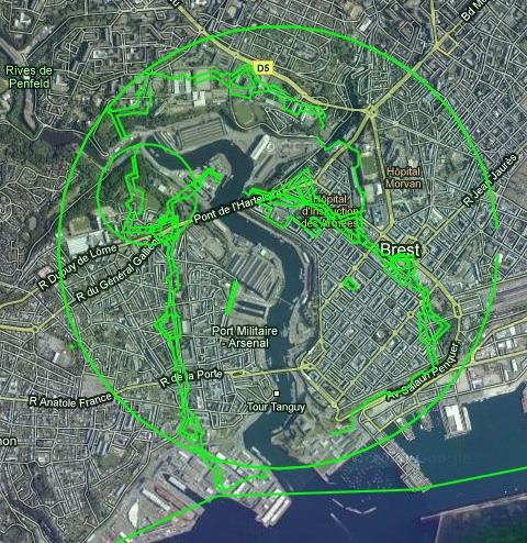
The castle still stands today. It has been transformed into a Navy museum, free to visit or with a guide (by appointment in the latter case). Its interest as an example of the work of Vauban is the fact that it illustrates the transformation of a medieval and ancient castle into a bastioned citadel. Of the urban wall, plots and the military port, all that remains is the building of the commissioners of the port. All other constructions were destroyed, either during the Second World War, or during the reconstruction which followed (1946-1961). The relief map of 1811 is preserved at the musée des Invalides of Paris.
Brest
Brest
48° 23' 27" N, -4° 29' 8" E
Type
urban wall, citadel and town planning
Engineers
Pietro Fredance, Julien Ozanne, Louis-Nicolas de Clerville, Pierre Chertemps de Seuil, Pierre Massiac de Sainte-Colombe, Sébastien le Prestre de Vauban, Desclouzeaux
Department
Finistère
Region
Bretagne
Bibliography
- DE ROUX (A.), Villes neuves, urbanisme classique, Paris, 1997.
- FAUCHERRE (N.), LECUILLIER (G.), La route des fortifications en Bretagne Normandie, Paris, 2006.
- LECUILLIER (G.), Les fortifications de la rade de Brest, défense d’une ville-arsenal, Rennes, 2011.
- RIBIERE (H.), « Le château de Brest » in Vauban et ses successeurs dans les ports du Ponant et du Levant : Brest et Toulon, Paris, 2000, p.265-270.
- RIBIERE (H.), « La défense du goulet de Brest » in Vauban et ses successeurs dans les ports du Ponant et du Levant : Brest et Toulon, Paris, 2000, p.271-284.
- SANGER (V.), « Vauban urbaniste : l’exemple de Brest » in Vauban et ses successeurs dans les ports du Ponant et du Levant : Brest et Toulon, Paris, 2000, p.17-49.
- WARMOES (I.), Le Musée des Plans-Reliefs, Paris, 1997.

