Briançon
History and description
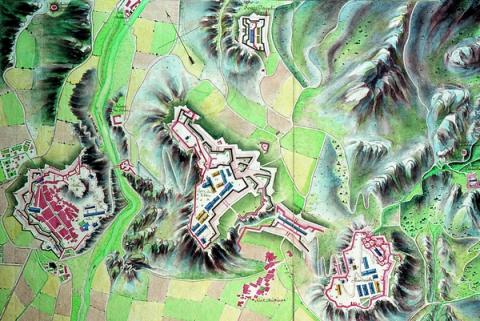
A town of Celtic origin, the first fortifications in Briançon were built during the Roman period. A small fort was constructed on the summit of the hillock which overlooked the Durance, at the point where five valleys intersected. This small fort was replaced by a medieval castle in the 16th century. The first urban wall was constructed between 1370 and 1395. In 1590, the Lesdiguières revolutionary took over Briançon and reinforced the castle. A century later, in 1689, the threat of the Dukes of Savoy, engaged in the League of Augsburg, prompted Louis XIV to modernise Briançon. These modernisations commenced with the construction of a first urban wall, fortified by the engineer Lagrune. This urban wall saw many segments of the medieval ramparts reused and was very narrow in itself, given the steep slopes in the vicinity of the walled town.In 1692, Vauban criticized this urban wall and suggested multiple improvements: the addition of a ravelin to the north, a guardroom at the porte de Pignerol, reinforcement of the bastions, a false rampart and a counterguard at the front of Embrun, with a gate more clearly defined than its predecessor. These constructions were completed around 1700. During a second passage in August of the same year, Vauban proposed a project with an even greater scope: the addition of a lower town to accommodate the garrison, the construction of an redoubt at the summit known as les Salettes, the addition of a hornwork in front of the castle, near the place known as champ de Mars, the creation of a more compact camp on the plateau des Têtes with a bridge for communication on the Durance. This was also the project in which he designed the collegiate church of Notre-Dame and the current Saint Nicolas. Knowing how pious those from Savoy tended to be, he placed them deliberately on the most exposed bastion of the urban wall, reinforced with a ravelin. The enemy would not dare to bomb a church.
The financial difficulties encountered at the end of the reign of Louis XIV meant the entire scope of this project could not be realised. Only the collegiate church (in 1703-1717) and the redoubt/fort (fort des Salettes) (in 1709-1712) would be constructed in line with the plans. As for the urban wall, it was realised in the form of modern ramparts including a front with a ravelin, which had a caponier and parados (to the north-west) and two fortified fronts preceded with a false rampart and then a moat, which was, itself, covered by a counterguard (to the west). In the town, to compensate for the lack of internal water, Vauban drilled a shaft up to the Durance, on the central square.
Under the Regency, military Engineering in France focused much attention on Briançon, a location which represented the first line after Savoy. Managed by the Marquis of Asfeld, three forts were constructed on the adjacent highlands, the occupation of which had been urged by Vauban. The engineer Tardif, head of the fortifications of Dauphiné, Nègre, head engineer of Briançon, and other engineers, including Heuriance and Boucet, oversaw the construction, from 1721 to 1735. The largest scale work they were responsible for was the fort des Trois Têtes (Three Heads fort). This fort was made up of three bastioned fronts turned toward the south-east and a hornwork equipped with an artillery battery (known as the bastion d’ Asfeld) which had the valley of the Durance under fire, four barracks, one of which set against a rocky outcrop, a chapel, a residence for the governor, a ravelin, a counterguard and a detached bastion. The most important side was the Royal front, which was where the main gate and the ravelin were found. Between the plateau des Têtes and the plateau du Randouillet, a construction known as Communication Y was built. This was a passageway vaulted as an experiment and allowing provisions to reach the fort de Randouillet from that the fort des Têtes and securing a means of passage between the two. The fort de Randouillet was an irregularly-shaped construction, including multiple barracks and magazines and a single fortified front to be recognised. To connect the fort des Têtes to the town, the pont d’Asfeld was constructed in 1730, which would round off the Vauban project. The fort Dauphin, square-shaped, was constructed to the north-east to complete the defences of the fort des Têtes.
The constructions of the 18th century remained incomplete. Multiple buildings planned in the projects of 1721 could not be constructed but that had been sufficed for the garrisons. A few small episodes of renovation (transforming a chapel into a barracks, adding vaults, filling in the central shaft in the town), would be implemented over the 19th and 20th centuries before the final demilitarisation of the fortified sites. Military cable cars were installed to connect the different forts. From 1873, five forts of the type Séré de Rivières were built at heights exceeding 2000 metres (fort de la Croix de Bretagne, fort de l’Enlon, fort des Gondrands, fort de l’Infernet and fort du Janus, the latter of which modernised in 1930 and included in the Alpine Maginot Line). In 1900, the Italians constructed the fort de Chaberton at an altitude exceeding 3,000 metres, against Briançon.
Current state
The majority of fortifications of the town still remain. The ramparts, the castle, the fort des Salettes, fort des Têtes, fort Dauphin, fort du Randouillet and Communication Y have been inscribed on the World Heritage List as part of the fortifications of Vauban. The urban wall is freely accessible all year round. Access to the Fort des Salettes, Fort des Têtes and Castle is restricted and only possible via guided tours. The other works are not currently open to visitors and preservation has proved problematic in many ways, since the army left. Multiple types of guided visits have been suggested: topical, historical, in costume, etc.
Briançon
Briançon
44° 53' 47" N, 6° 38' 8" E
Type
urban wall and detached forts
Engineers
Hue de Langrune, Sébastien le Prestre de Vauban, Jacques Fitz-James duc de Berwick, Claude François Bidal Marquis d’Asfeld, Tardif, Nègre, Heuriance, Boucet
Department
Hautes-Alpes
Region
Provence-Alpes-Côte d'Azur
Bibliography
- BARDE (Y.), Histoire de la fortification en France, Paris, 1996.
- BODIN (B.), BRUNO (C.), Briançon, Vauban et son empreinte, Grenoble, 2006.
- BODIN (B.), FAUCHERRE (N.), Vauban, Les sites majeurs, Grenoble, 2007.
- BORNECQUE (R.), FAUCHERRE (N.), La route des fortifications dans les Alpes, Paris, 2006.
- BORNECQUE (R.), Vauban et les Alpes, Saint-Léger-Vauban, 1995.
- BORNECQUE (R.), Briançon, sentinelle des Alpes, Veurey, 2006.
- Briançon, ville forte du Dauphiné, de l’Antiquité au Traité d’Utrecht, s. l., 2006.
- PISSARD (I.), VILLECOURT (A.), La montagne fortifiée, le Briançonnais : un conservatoire unique de la fortification de montagne, projet d’inscription au patrimoine mondial de l’UNESCO, s. l., 2001.
- Vauban et ses successeurs en Briançonnais, Paris, 1995.
- WARMOES (I.), « Le plan-relief de Briançon » in L’échauguette, n°34, Briançon, 1999.
- WARMOES (I.), Le musée des plans-reliefs, Paris, 1997, p.48.

