Dunkerque (Dunkirk)
History and description
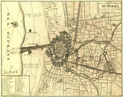
From a small fishing village in the 7th century on the North Sea coast, the first urban wall built around Dunkirk came in 960, in the form of a fenced moat. The town developed based on an orthogonal layout. It was not until 1405 until it had its own octagonal masonry urbanwall with twenty-eight towers. Having become a border town, Dunkirk kept its urban wall, said to be of Burgundy until 1640. Charles Quint later created an initial stronghold there in 1548. His Spanish successors then added barracks to the same in 1611. The town was besieged several times by the French, Spanish and English. In 1640, a new urban wall was constructed to replace the Burgundy ramparts. In 1644, the Léon fort was constructed outside the entrance to the harbour to bolster the coastal defences. But all this building could not prevent Dunkirk falling to the French in 1646. The Spanish went on to recapture it six years later, but the English seized power in 1658. They then proceeded to replace the Léon fort with the irregular five-sided citadel, which would see the port closed from then on. Four years on, France bought Dunkirk.The first building instigated by Vauban was the completion of the English citadel from 1662 to 1666. This work was carried out by the engineers La-Motte-La-Mye and Chastillon. The enclosure was reconstructed and included ten bastions. The area it enclosed was also greater than its predecessor. Work on constructing the new ramparts started in 1668, and was completed in 1683 with the demolition of the medieval walls. Two square forts were also constructed upstream of the town, along the Bergues canal: the fort Louis and fort Vallière.
1665 saw the first town planning projects established, which would unfold in multiple phases until 1700. With the details approved by Louis XIV in 1681, the final plan was designed by Vauban in 1686. The basics of this plan were as follows: first, the diversion of the estuary and the rivers running into the same, via locks, followed by the construction of a new shipyard upstream of the old port and the construction of an arsenal (set up from 1685) with armouries and rope factory. This was also the time when the neighborhoods of the new town and the lower town started taking shape. The former was in the form of a flexible orthogonal model, linked to the old town by two squares, the place Royale (‘Royal Square’) and the place Dauphine (‘Dauphine Square’), home not to arms but to markets. While no architectural regulation was prescribed for this construction, standards were certainly applied nonetheless. For the lower town, the model eventually adopted was a fanned-out shape, due to the layout of the channels. The development did not include any squares, the point where the streets came together was the cemetery. This final urban development was prompted by the expansion of the port, which was intended to separate the middle-class of Dunkirk from the seamen, those working at the arsenal and the farmers from the villages levelled by the extension of the town. The presence of all those mentioned, alongside the growth of the navy and French commerce, saw the Dunkirk population double between 1662 and 1685. However, this attempt at urban expansion was relatively unsuccessful, since the old town continued to grow during the 17th century in the form of new constructions set up in existing districts. The streets were all laid out in 1700 but not all the land was built on. In 1713, the destruction of the ramparts as the treaty of Utrecht was adopted saw the local population drop.
The urban growth resurfaced in the years that followed, until in 1740, all of the land originally laid out by Vauban had been occupied. A hospital and the intendancy buildings were also constructed as part of the urban development. Moreover, a further district was added in 1754, when the expansion of the 17th century had reached its limit. In 1785, a further urban project aiming to divide up the newly gained land from the demolition of the ramparts was put forward but abandoned with the Revolution. A final encircling wall was constructed during the Restoration, and completed in 1830.
Current state
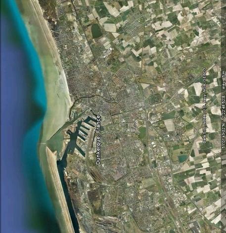
Nothing was left of Vauban’s Dunkirk, save a barracks and the urban outlines. All the ramparts and military buildings were demolished from the 19th century to create boulevards (‘avenues’). The two World Wars and the reconstruction which followed them were integral in this destruction. The two detached forts still exist, albeit only the outer ramparts. They have been integrated into the urban parks.
Dunkerque
Dunkerque
51° 2' 18" N, 2° 22' 39" E
Type
citadel, urban wall, town planning, detached forts, military port
Engineers
Sébastien le Prestre de Vauban
Department
Nord
Region
Hauts-de-France
Bibliography
- BONDUELLE (A.), FAUCHERRE (N.), et alii, Dunkerque, dunes, briques et béton, s. l. 1995.
- DE ROUX (A.), Villes neuves, urbanisme classique, Paris, 1995.
- LEMAIRE (L.), Histoire de Dunkerque : des origines à 1900, Dunkerque, 1927.
- MERCK (A.), La citadelle de Dunkerque, Dunkerque, 1996.
- PETER (J.), Vauban et Dunkerque, Paris, 2000.

